
Cerro Otto is a climb of 9.5 kilometers (hors catégorie). Cerro Otto tops out at 1,391 m above sea level. It is located in San Carlos de Bariloche, Río Negro, Argentina. The average gradient is 6.4% with a maximum of 16.6%. The climb has 611 meters of elevation gain.
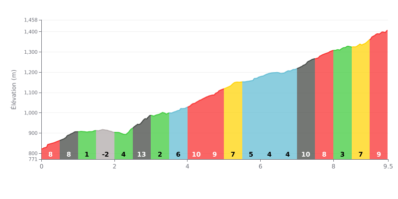
Difficulty breakdown: This HC climb is seriously hard, with an average gradient of 6.4% over 9.5 km. The main challenge is how uneven the profile is: very steep sections (12% at KM 2.5-3.0, 10% at KM 4.0-4.5 and 7.0-7.5) alternate with flat stretches and even a short descent, which makes it hard to find a rhythm.
How to manage the effort:
1. Anticipate the gradient changes: Keep something in the tank on the 4-5% sections so you can attack the 10-12% ramps, especially the one in the third kilometre.
2. Pace yourself over the full climb: The finale is tough (8-9% over the last kilometre). Don't go too hard in the first half or you'll have nothing left at the end.
3. Use the recovery sections: The low-gradient stretches (KM 1.0-2.0) are key for recovering and bringing your heart rate down before the hard segments.
Riders who have climbed Cerro Otto describe a tough but rewarding climb, on a gravel and rock track (ripio) that keeps going up. The road is passable for cars, but it's narrow, twisty, and has some pretty steep sections that test your calves and your lungs. For some, the final stretch, which is especially steep with loose surface, made for slow going, but the sense of accomplishment at the top is unanimous.
The payoff matches the effort: a breathtaking panoramic view over the city of Bariloche, Lake Nahuel Huapi, and the surrounding mountain range. Riders agree that the scenery, especially on a clear day, is simply spectacular and is the highlight of the ride. The climb itself already offers some great viewpoints along the way.
This climb is presented as an adventure that's accessible in several ways. You can take the main track straight up, but other reports mention alternative trekking trails that also let you reach the summit on a bike, although some can be very technical and are best left to experienced riders. So you can tailor your route to your level and what you feel like riding.
Cyclists appreciate the wild and authentic side of this climb, far from the crowds of the cable car. However, they stress the need to stay alert to the occasional traffic on the ripio road, which can be narrow in places. Once at the top, access to the famous confitería giratoria (rotating café) is paid if you don't take the cable car, a detail to know if you plan to stop there.
9.5 km • 611 m D+
VAM: average climbing speed, based on elevation gain


Join thousands of cycling fans! Plan your rides, record your performance, track your progress and discover the finest climbs.
Live climb profile to pace your effort all the way to the top.

