
Macskakő is a climb of 3.4 kilometers (category 3). The climb finishes at 450 m above sea level. It is located in Salgótarján, Alföld és Észak, Magyarország. The average gradient is 4.0% with a maximum of 12.6%. The climb has 133 meters of elevation gain.
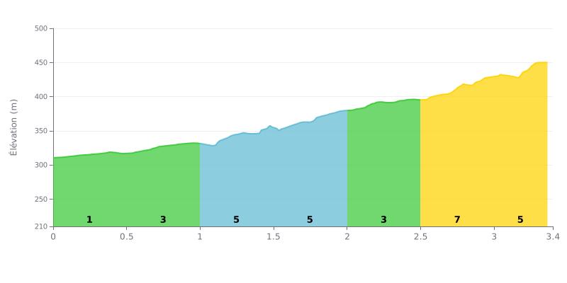
Difficulty breakdown: With 3.4 km for 133 m of elevation gain and an average gradient of 4%, this climb is Category 3: doable, but it will test you. The start is rolling at 1% over km 0.0-0.5, which gives you time to find your rhythm. The gradient then ramps up gradually, with 5% over km 1.5-2.0, followed by 7% over km 2.5-3.0, the steepest section of the climb. Km 3.0-3.4 at 6% offers no respite all the way to the top.
Tips for managing your effort:
1. Save your legs at the bottom: over km 0.0-0.5, spin easy in a light gear so you reach the hardest part with fresh legs.
2. Pace yourself on the steep ramp: over km 2.5-3.0 at 7%, stay seated if you can, keep a steady cadence and avoid unnecessary surges.
3. Empty the tank at the end: over km 3.0-3.4 at 6%, keep your breathing under control and save what you have left for the last 100 metres.
3.4 km • 133 m D+
VAM: average climbing speed, based on elevation gain


Join thousands of cycling fans! Plan your rides, record your performance, track your progress and discover the finest climbs.
Live climb profile to pace your effort all the way to the top.

