
Tetero is a climb of 3.4 kilometers (category 1). Tetero tops out at 2,282 m above sea level. It is located in Ruhunde, Northern Province, Rwanda. The average gradient is 6.9% with a maximum of 17.4%. The climb has 237 meters of elevation gain.
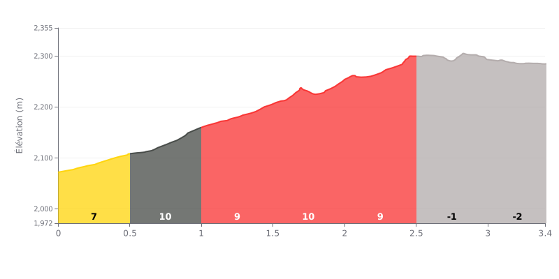
Difficulty breakdown: Tetero from Ngoma is a 3.4 km climb with 237 m of elevation gain, averaging 6.9%, which puts it in Cat 1. Most of the work is between km 0.0 and km 2.5, where the gradient sits between 7% and 11%. The steepest section is the 0.5-1.0 km stretch at 11%. From km 2.5 to km 3.4 it drops, giving you a breather before the finish. The real challenge is holding a steady effort for more than two kilometres at a sustained gradient.
Pacing tips:
1. Ease into it. On the 0.0-0.5 km section at 7%, sit in your aerobic zone so you don't blow up on the 11% ramp that follows.
2. Keep a smooth cadence through the heart of the climb. Between 0.5 and 2.5 km, with gradients of 9 to 11%, pick a gear you can spin comfortably and avoid surging and fading.
3. Recover, then push on the final section. Use the 2.5-3.4 km descent to recover, then build back up gradually without burning your last reserves.
3.4 km • 237 m D+
VAM: average climbing speed, based on elevation gain


Join thousands of cycling fans! Plan your rides, record your performance, track your progress and discover the finest climbs.
Live climb profile to pace your effort all the way to the top.

