
Mount Hillaby is a climb of 6.8 kilometers (category 2). The climb finishes at 333 m above sea level. It is located in Rock Hall, n/a, Barbados. The average gradient is 3.4% with a maximum of 12.8%. The climb has 231 meters of elevation gain.
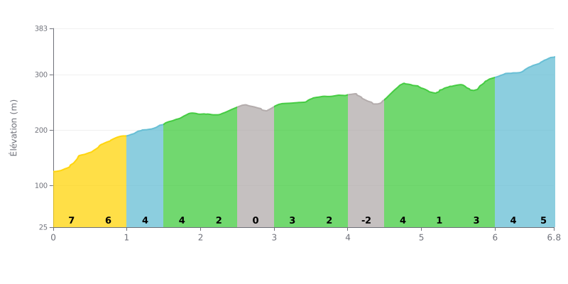
Difficulty breakdown: Mount Hillaby from Blowers is a Category 2 climb of 6.8 km with 231 m of elevation gain, at an average gradient of 3.4%. The start is the hardest section: km 0.0-0.5 at 7% and km 0.5-1.0 at 6% demand a sustained effort right from the first minutes. The rest alternates between rolling sections, such as km 2.5-3.0 at 0%, and a steeper finish between km 6.0-6.5 (4%) and km 6.5-6.8 (5%). The climb has no major technical difficulty, but it requires good effort management over the duration.
Tips for pacing the climb:
1. Ease into it On the km 0.0-0.5 section at 7%, going out too hard will cost you later on.
2. Recover on the flat bits Use the km 2.5-3.0 section at 0% and the km 4.0-4.5 section, which dips slightly (-1%), to recover and settle back into a steady rhythm.
3. Save something for the finish The km 6.0-6.5 (4%) and km 6.5-6.8 (5%) sections come after several kilometres of climbing, so keep enough in the tank to hold your pace through them.
Cyclist reports on Mont Hillaby are mostly about hiking, and several don't mention riding at all. Keep that in mind before planning a ride.
The point that comes up most is that Google Maps puts the summit in the wrong place. According to two people, the real summit is at 13°12'40.2"N 59°34'56.3"W. To get there, follow the road named after Hillaby all the way to the end, starting from Hillaby (13°12'40.2"N 59°35'28.1"W), then climb the bank on the south side. One witness says they found a US geodetic survey marker dating back to the 1950s there.
One cyclist says he went through a muddy grass field in a rental car, then walked back down. There was a lot of mud, and locals told him the "shortcut" road to the summit was closed that day. They advised him to head back down to the bay and the northern bus stop, then climb up again, which they estimated at about an hour on foot. His group gave up, short on time.
Those who made it to the top describe an beautiful and quiet area that is best explored on foot. Another witness did a 6.5-mile loop, about 10.5 km, and found it pleasant. Beyond that, the reports are too brief or vague to say anything reliable about the climbs, the road surface, or traffic.
6.8 km • 231 m D+
VAM: average climbing speed, based on elevation gain


Join thousands of cycling fans! Plan your rides, record your performance, track your progress and discover the finest climbs.
Live climb profile to pace your effort all the way to the top.

