
Gubalowka is a climb of 9.1 kilometers (category 1). Gubalowka tops out at 1,126 m above sea level. It is located in Ratułów, województwo małopolskie, Polska. The average gradient is 4.4% with a maximum of 12.1%. The climb has 397 meters of elevation gain.
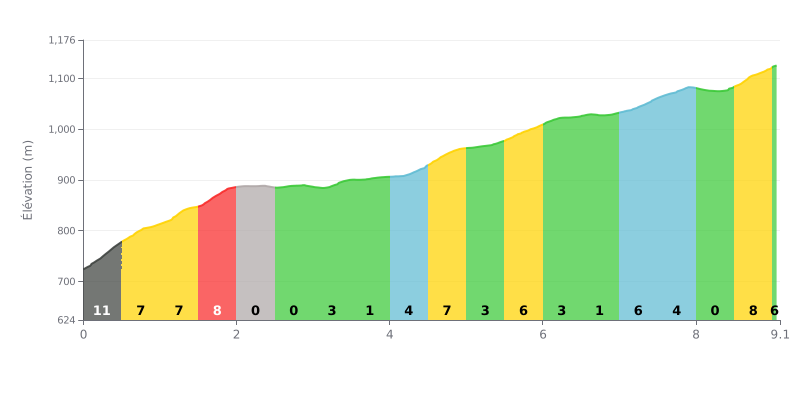
Difficulty breakdown: The Gubalowka from Ratułów is a 9.1 km climb with 397 m of elevation gain, averaging 4.4%, which puts it in Cat 1. The start is brutal, with 11% over the first 500 metres (KM 0.0-0.5), followed by several sections between 7 and 8% (KM 0.5-1.0, KM 1.0-1.5 and KM 1.5-2.0). The profile is mostly uneven: the flat sections at 0% (KM 2.0-2.5 and KM 2.5-3.0) break your rhythm, and the climb finishes with an 8% ramp (KM 8.5-9.0).
Pacing tips:
1. Handle the start. Don't go out too hard on the 11% section of KM 0.0-0.5, and pick a gear that lets you keep a steady cadence.
2. Make use of the false flats. Use the 0% sections of KM 2.0-2.5 and KM 2.5-3.0 to recover a little and find a steady rhythm again before what's coming.
3. Save something for the finish. Don't waste your legs on the 7% surges of KM 5.5-6.0, so you still have something left to attack the 8% ramp of KM 8.5-9.0.
Riders who have climbed Gubałówka agree on one thing: the view from the top is simply breathtaking. The reward for the effort is a 360-degree panorama over Zakopane and the Tatra range, a sight that, on a clear day, stays with you for a long time. Many recommend the sunset in particular, when the light hits the peaks.
The climb itself is described as doable, but not a walk in the park. Several riders mention that the road can be steep and demanding in places, especially if you choose to hike up the trails rather than take the funicular. For a more relaxed outing, particularly with family, the funicular from the centre of Zakopane gets a lot of praise: quick, convenient, and already offering good views on the way up.
Once at the top, the atmosphere is two-sided. On one hand, it's a very lively scene, with plenty of food stalls (grilled oscypek), souvenir shops, and activities like the summer toboggan. This fairground side can put off those looking for the quiet of nature. On the other hand, you can always walk a little way off to find a bench and enjoy the scenery in peace. Prices up top are often reported as a bit higher than down below.
The most common advice? Pick a weekday to avoid the crowds, especially in high season when weekends can get very busy. And if you go in winter, many riders mention the "Kraina Światła" (the Land of Light), a magical illumination that turns the place into a fairy-tale landscape once night falls.
9.1 km • 397 m D+
VAM: average climbing speed, based on elevation gain


Join thousands of cycling fans! Plan your rides, record your performance, track your progress and discover the finest climbs.
Live climb profile to pace your effort all the way to the top.


Other climbs to Gubalowka