
Jaram Pass is a climb of 23.4 kilometers (hors catégorie). Jaram Pass tops out at 1,802 m above sea level. It is located in Raška, n/a, Србија. The average gradient is 6.1% with a maximum of 15.7%. The climb has 1415 meters of elevation gain.
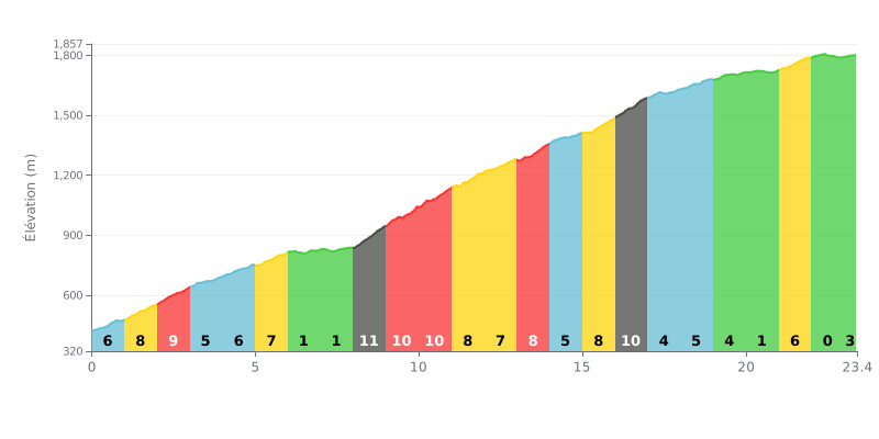
Difficulty breakdown: At 23.4 km with 1415 m of elevation gain and an average gradient of 6.1%, the Jaram Pass from Rudnica is an HC climb that's tough mainly because of its length. The real crux is the middle section, km 8 to km 11, where the gradient sits between 10% and 11% for over 3 km straight. Km 16-17 at 10% is the second major test, before the final part eases off into a more progressive gradient.
Pacing tips:
1. Hold back early. Km 1 to 3, at 6% to 9%, will tempt you to go too hard when there's still over 20 km to climb.
2. Recover on the flat sections. Km 6-7 and 7-8 (1%) are your chance to drink, eat and get your legs back before the 10-11% block from km 8 to km 11.
3. Manage the finish. After km 17-18 (4%), keep a steady effort through to km 22, then use the flat at km 22-23 (0%) to go again before the final 400 metres at 3%.
For riders looking for an accessible climb, testimonials point to Jaram as an excellent choice, described as a "great track for beginners", a superb road for newcomers to climbing.
Climbers who've ridden it describe a "Nice Blue track", suggesting a pleasant, well-marked road that seems to be a near-essential stretch if your goal is to reach the Gobelja pass.
The atmosphere up there isn't purely cycling; testimonials mention a spot "Nice for skiing" where you can run into hikers (🚶♀️) as well as skiers (⛷️), which paints the picture of a lively place, enjoyed for different outdoor activities depending on the season.
The climb therefore seems to offer a versatile experience, on a road valued for its accessibility and its role as the approach route to other iconic destinations.
23.4 km • 1415 m D+
VAM: average climbing speed, based on elevation gain


Join thousands of cycling fans! Plan your rides, record your performance, track your progress and discover the finest climbs.
Live climb profile to pace your effort all the way to the top.

