
Cuesta Aculeo is a climb of 3.9 kilometers (category 1). Cuesta Aculeo tops out at 619 m above sea level. It is located in Rangue, Región Metropolitana de Santiago, Chile. The average gradient is 6.8% with a maximum of 16.6%. The climb has 269 meters of elevation gain.
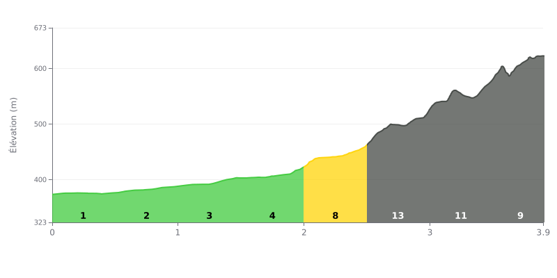
Climb analysis: This Category 1 climb has a progressive but significant difficulty. The first half (0-2 km) is fairly manageable, with gradients of 1% to 4%, and serves as a warm-up. The difficulty ramps up sharply in the second half, with a demanding section from 2 to 3.5 km where the gradient stays above 8% the whole way, peaking at 13% between 2.5 and 3 km. This 1.5 km stretch of steep gradient is the heart of the climb.
Pacing tips:
1. Manage your pace: Use the first two kilometers to settle into a steady rhythm without burning matches. Be ready for the sudden jump in gradient around the 2 km mark.
2. Save something in the tank: The hardest effort comes between 2.5 and 3.5 km. Don't blow up on the 13% kilometer. Pace yourself on the 8% section leading into it.
3. Save some legs for the finish: The gradient eases to 9% over the final 400 meters, so you can kick again if you've held something back.
According to the riders who have climbed it, the ascent to Laguna de Aculeo offers a unique landscape, surrounded by mountains and the Cordillera de la Costa. Even though the lagoon itself has gone through severe dry spells, many riders have been lucky enough to see it fill up again, which makes the view particularly stunning.
The climb is described as quiet and soothing, a real escape close to Santiago. Riders stress how calm the place is, perfect for connecting with nature, where you can hear the birds singing and breathe clean air, far from the city noise.
On the other hand, riders point to a major logistical challenge: access to the lagoon is largely private. Riding the full loop can be frustrating, as you often have to go through campsites or private properties, sometimes paying an entry fee, to get near the water's edge.
The condition of the road around the lagoon is variable and can be technical. Some reports mention a narrow dirt track, with muddy sections in winter or dusty ones in summer, and sometimes in poor shape. Caution is advised, especially since cows may wander onto the road.
Despite the access restrictions, riders often come away feeling they've discovered a magical, unspoiled spot. The beauty of the setting, especially when the water is there, and the feeling of total tranquility make this climb memorable for those who manage to enjoy it.
3.9 km • 269 m D+
VAM: average climbing speed, based on elevation gain


Join thousands of cycling fans! Plan your rides, record your performance, track your progress and discover the finest climbs.
Live climb profile to pace your effort all the way to the top.

