
Havran is a climb of 3.9 kilometers (category 4). The climb finishes at 390 m above sea level. It is located in Radošina, Nitriansky kraj, Slovensko. The average gradient is 4.2% with a maximum of 7.3%. The climb has 163 meters of elevation gain.
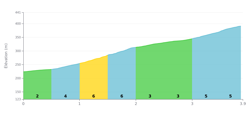
Difficulty analysis: At 3.9 km, with an average gradient of 4.2% and 163 m of elevation gain, the climb to Havran from Radošina is rated Category 4 and remains doable for most amateur riders. The profile is uneven: after a gentle start at 2% on KM 0.0-0.5, the sections KM 0.5-1.0, KM 1.0-1.5 and KM 1.5-2.0 pitch up between 5 and 6%. The gradient then eases to 3% on KM 2.0-2.5 and KM 2.5-3.0, before a finish at 5% on KM 3.0-3.5 and KM 3.5-3.9. The col is hard mainly because of its succession of surges.
Pacing tips:
1. Don't go out too hard. On KM 0.0-0.5, at 2%, settle into a steady rhythm so you've got some left in the tank for the steepest part.
2. Manage the hardest section. On KM 1.0-1.5 and KM 1.5-2.0, at 6%, stay in the saddle, spin a smooth cadence and avoid jerky pedal strokes.
3. Recover before the final push. Use the 3% stretches on KM 2.0-2.5 and KM 2.5-3.0 to ease back up the gears and tackle the 5% finish on KM 3.0-3.5 and KM 3.5-3.9 with legs still fresh.
Havran Pass sits on the border between the Nitra and Trnava regions, on the road that leaves from Piešťany. Those who've ridden up it mostly talk about it as a jumping-off point for an outing on foot, on the mountain bike or on the road, with forests, singletrack and views over the hills around.
For mountain biking, the feedback is good. One rider mentions plenty of forest tracks in good condition, and another finds the pass super for riding. The trails are well marked, and the route can be downloaded from mapy.cz for offline use. The car park is free but unattended.
In spring, wild garlic grows in quantity around the pass, according to those who passed through during the flowering. From the summit, riders name the Smolenice hills, Veľký Plešivec, Slnava and Piešťany. In autumn, the air is crisp and the atmosphere is pleasant.
The weak point comes up often: the restaurant at the pass. Several reports say it has been closed for a long time and is in poor shape, and one rider only found shelter there during a thunderstorm. One rider recommends the Furman restaurant, further along the road, as the place to stop and eat.
On the traffic side, one rider reports that motorcyclists don't respect the rules of the road. There are also roadworks in progress on the road towards Piešťany, and a notice announces a one-year repair, with restricted passage because of the surface and slippery sections.
3.9 km • 163 m D+
VAM: average climbing speed, based on elevation gain


Join thousands of cycling fans! Plan your rides, record your performance, track your progress and discover the finest climbs.
Live climb profile to pace your effort all the way to the top.

