
Swartberg Pass is a climb of 3.2 kilometers (category 2). Swartberg Pass tops out at 1,557 m above sea level. It is located in Prince Albert Local Municipality, Western Cape, South Africa. The average gradient is 6.6% with a maximum of 14.1%. The climb has 209 meters of elevation gain.
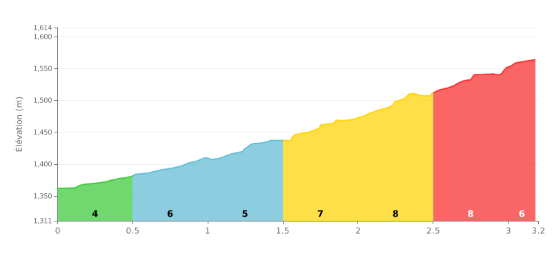
Difficulty breakdown: This Category 2 climb ramps up progressively. The gradient climbs steadily from 4% over the first half kilometer to 8% in the central section (KM 2.0-3.0), which is the real meat of the climb, with almost 1 km at 8%. The final section eases slightly to 6%, giving you a bit of relief before the summit.
Pacing advice:
1. Start easy: Use the first 500m at 4% to settle into your rhythm without going into the red.
2. Save something for the hard part: Keep your legs fresh for the tough section from KM 1.5 to 3.0 (gradients of 7% and 8%).
3. Keep something in the tank: The last segment at 6% lets you finish strong, provided you've paced the effort well.
According to riders who have climbed it, the ascent of Swartberg Pass is a both punishing and unforgettable experience. The side from Prince Albert is described as a treacherous, very steep climb, on a narrow road that is sometimes single-lane, testing both the mind and the legs. Riders describe a huge rush on reaching "Die Top", the summit at over 1500 metres, a moment of relief and deep reflection.
What makes this climb special is the breathtaking scenery that rewards every effort. Riders describe 360-degree panoramic views over mountains with spectacular rock formations, with layers of red, orange and brown strata. The road snakes through this majestic landscape, offering a new viewpoint around every bend, each more impressive than the last, "a masterpiece of nature".
Road surface is a key point raised by riders. It's a gravel track, "holprig" (bumpy) according to some. Most agree that a mountain bike is strongly recommended, especially for the technical descent toward Prince Albert, although it's doable on a gravel bike for the more experienced. Caution is essential because there are no guardrails along much of the route.
The atmosphere on the pass is that of a genuine, solitary adventure. Many riders recommend setting out early in the morning to avoid traffic, although it's usually light. Encounters with small wildlife (birds, tortoises, rock hyraxes) add to the wild character of the experience. For many, it's far more than a simple climb; it's a spiritual journey that leaves a lasting mark.
Despite the difficulty, riders are unanimous: it's an absolute "must-do". They come away feeling they have experienced something unique, an adventure that confronted them with the raw harshness and beauty of nature. The advice is clear: take your time, stop often to capture the scenery, and let yourself be carried away by the magic of the place.
3.2 km • 209 m D+
VAM: average climbing speed, based on elevation gain


Join thousands of cycling fans! Plan your rides, record your performance, track your progress and discover the finest climbs.
Live climb profile to pace your effort all the way to the top.

