
Teyuna - Peaje la Punta is a climb of 19.2 kilometers (hors catégorie). Teyuna - Peaje la Punta tops out at 1,670 m above sea level. It is located in Piedecuesta, Santander, Colombia. The average gradient is 7.0% with a maximum of 15%. The climb has 1346 meters of elevation gain.
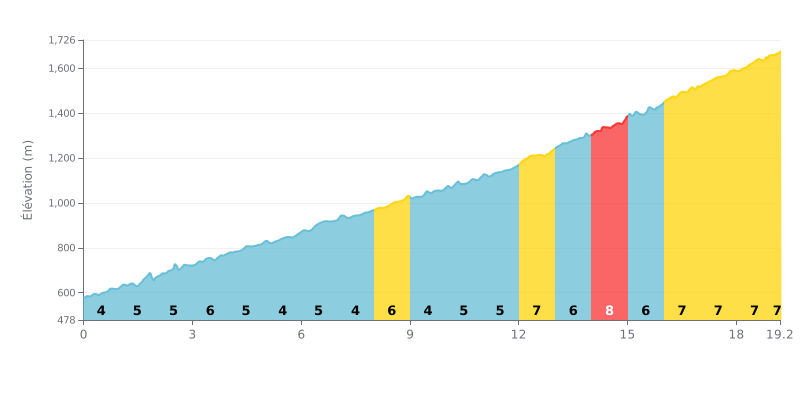
Difficulty breakdown: This HC climb covers 19.2 km for 1346 m of elevation gain, with an average gradient of 7%. From km 0 to km 11, the gradient stays between 4% and 6%, which can tempt you to go out too hard. The real difficulty is concentrated in the second half, from km 12 to km 19.2, where the gradient ranges from 6% to 8% with no respite.
Tips for managing your effort:
1. Settle into a steady rhythm from the start. Over the first kilometres (km 0 to 11), hold a constant pace so you have something left in the tank for the hardest section.
2. Take km 14 to 15 calmly. At 8%, this is the steepest stretch: spin a light gear with a high cadence and don't mash the pedals.
3. Save something for the summit. From km 16 to km 19.2, the gradient holds steady at 7%. Keep fuelling and drinking regularly over the full 19 km so you reach the Peaje la Punta with a clear head.
For the cyclists who have climbed it, the ascent to Peaje La Punta is a demanding and rewarding challenge, often tackled in a group to better handle the sustained gradient, especially under a midday sun. The reward at the summit is well worth the effort put in.
This climb is the must-do route to discover La Mesa de los Santos, a region known for its great climate, its spectacular scenery and its tranquility. Riders' accounts describe a viewpoint offering a breathtaking view over Bucaramanga and Piedecuesta, a perfect spot to clear your head and recharge in a soothing natural setting.
The cycling vibe is real: the pass is a must-stop meeting point. Just past the toll booth, strategically placed tiendas let you refuel with a coffee or a cold drink, and get some energy back with empanadas, rellenas or chorizos, which riders mention as delicious.
Riders do report some realistic downsides, though. The road surface is often criticized for poor maintenance, with potholes and signage considered insufficient. On top of that, traffic can cause jams, especially on weekends and public holidays, which can slow the descent and calls for extra caution.
Despite the pricey toll and the road's hazards, the overall experience remains positive for many cyclists. It combines the demands of a proper mountain pass with the beauty of the landscapes and the friendly atmosphere of a gathering spot, making this climb a local classic worth discovering.
19.2 km • 1346 m D+
VAM: average climbing speed, based on elevation gain


Join thousands of cycling fans! Plan your rides, record your performance, track your progress and discover the finest climbs.
Live climb profile to pace your effort all the way to the top.


Other climbs to Teyuna - Peaje la Punta
Within 20 km