
Túnel Las Palmas is a climb of 26.2 kilometers (category 1). Túnel Las Palmas tops out at 1,032 m above sea level. It is located in Pedegua, Región de Valparaíso, Chile. The average gradient is 2.9% with a maximum of 10.7%. The climb has 767 meters of elevation gain.
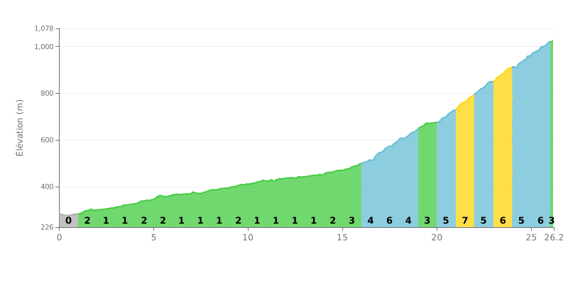
Difficulty breakdown: This 26.2 km climb has two distinct phases. The first 15 km (average gradient 1-2%) is a long, easy approach. The real difficulty, typical of a Category 1, is concentrated in the last 11 km, where the gradient consistently stays above 5%, with a peak at 7% between km 21 and 22.
Pacing advice:
1. Managing your pace on the first section: Resist the urge to hammer the first 15 km. Use this stretch to find a steady rhythm and save your legs.
2. Preparing for the change of pace: From km 15, the gradient gradually ramps up (3%, then 5%). Increase your cadence and shift into an easier gear so you can tackle the steepest part calmly.
3. Focusing on the final kilometres: The sections at 6-7% between km 21 and 26 are decisive. Hold a steady power output and avoid surges to keep your legs fresh until the summit.
Cyclists who have ridden through the Túnel Las Palmas describe an experience like no other, almost a trip back in time. This roughly 1 km long tunnel, a former railway line and a national monument, bores through the mountain with a rustic, mysterious feel, plunged into total darkness. For many riders, it's a first: riding through a structure this narrow and dark is an adventure in itself.
The climb is punctuated by a traffic light system that alternates the direction of travel, a necessity for this single-lane passage. However, riders' reports stress that the system isn't always reliable or respected. Some have had the bad luck of meeting a vehicle inside the tunnel, forcing them to back up several hundred metres. Caution is therefore essential, especially since the entrance sometimes comes right after a bend.
But the effort is more than repaid by the scenery surrounding the tunnel. The road, generally described as being in good nick and well signposted, winds between green valleys, especially after the rain, and offers superb views over hillsides covered in Chilean palms. It's not unusual to spot condors soaring above this unspoiled setting.
Despite its charm, the experience isn't perfect for everyone. Some point to the presence of litter left behind by visitors, a lack of respect for this historic and natural site. Moreover, the state of the road surface inside the tunnel can vary; some mention water or uneven patches, advising caution for low-clearance vehicles.
All in all, for cyclists, it's a must-do stage that combines history, effort and emotion. Riding over this pass means taking a road full of stories, linking the regions in an atmosphere that is both serene and adventurous, provided you stay alert and respect the traffic rules.
26.2 km • 767 m D+
VAM: average climbing speed, based on elevation gain


Join thousands of cycling fans! Plan your rides, record your performance, track your progress and discover the finest climbs.
Live climb profile to pace your effort all the way to the top.

