
Sadhutar Panchtar is a climb of 5.2 kilometers (hors catégorie). Sadhutar Panchtar tops out at 2,492 m above sea level. It is located in Pauwasartap, कोशी प्रदेश, नेपाल. The average gradient is 8.4% with a maximum of 12.9%. The climb has 434 meters of elevation gain.
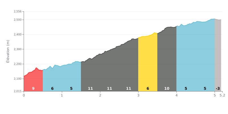
Difficulty analysis: With 5.2 km and 434 m of elevation gain at an average gradient of 8.4%, this climb is rated HC and proves punishing from start to finish. The real crux comes between KM 1.5 and KM 3.5, with three consecutive sections at 11% (KM 1.5-2.0, 2.0-2.5 and 2.5-3.0), followed by KM 3.5-4.0 at 10%. The more rolling stretches at 5% (KM 1.0-1.5, 4.0-4.5 and 4.5-5.0) give you a few breathers, but the pace stays hard all the way to the summit.
Tips for the effort:
1. Pace the start Over KM 0.0-0.5 at 9%, don't go out too hard, or you'll have nothing left for the central block.
2. Handle the 11% block Between KM 1.5 and 3.0, select an easy gear, keep a steady cadence and breathe calmly so you can hold it together without going into the red.
3. Recover and push on Use the 5% stretches from KM 4.0 to KM 5.0 to refill the tank and get ready for the final hundred metres before the top.
For cyclists who have climbed it, the ascent to Sadhutar Panchthar is an authentic and demanding adventure. The road leaving Pauwa Bhanjyang is described as a dirt track of roughly 1.5 to 3 km, tough going, especially on a road bike, and turned slippery during the rainy season. But those who push through agree the effort is more than worth it.
At the top, riders describe a breathtaking reward: a 360° panorama of Everest, Makalu, Kanchenjunga and Kumbhakarna. The small pond, though sometimes described as polluted, mirrors the blue sky and the Himalayan range on clear days, creating a landscape of magical serenity. The place is so peaceful that some cyclists felt like they were "touching the sky".
The vibe is that of a still-preserved, rustic spot. Riders report that there are only one or two very basic homestays up there, with limited food options. There's practically no infrastructure such as benches or shelters. That simplicity is part of the charm, but it calls for careful logistical planning, especially if several groups show up at the same time.
Cyclists stress how much the weather matters: on a clear day the view is unforgettable, but fog can ruin everything. Many also point out a downside: the rubbish around the pond, which spoils the experience for some. Their message is clear: this is a natural gem that deserves to be protected.
Despite the access difficulties and the lack of comforts, the overall experience is described as unique and mesmerizing. Riders come away feeling they've discovered a hidden gem, a perfect place to reconnect with raw, spectacular nature, far from the hustle. For them, it's a climb that leaves a lasting mark.
5.2 km • 434 m D+
VAM: average climbing speed, based on elevation gain


Join thousands of cycling fans! Plan your rides, record your performance, track your progress and discover the finest climbs.
Live climb profile to pace your effort all the way to the top.


Other climbs to Sadhutar Panchtar