
Pasir Luhur is a climb of 5.1 kilometers (category 1). The climb finishes at 1,069 m above sea level. It is located in Pasanggrahan, Jawa Barat, Indonesia. The average gradient is 7.4% with a maximum of 17%. The climb has 377 meters of elevation gain.
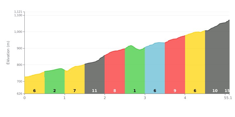
Difficulty breakdown: The Pasir Luhur from Sekemala is a 5.1 km climb with 377 m of elevation gain at an average gradient of 7.4%, which puts it in Category 1. The real difficulty is the consistency of the effort, as the gradient stays honest for most of the climb, with sections at 11% between km 1.5 and 2.0 and again between km 4.5 and 5.0. The final push, at 15% over the last 107 metres (km 5.0-5.1), is the hardest point of the climb.
Pacing tips:
1. Don't go out too hard On the km 0.0-0.5 section at 7%, keep your effort under control so you have something left for the steeper stretches.
2. Make the most of the breather on km 0.5-1.0 At just 1% gradient, this section is your chance to drink, eat something and get your breath back before the 8% ramp that follows.
3. Save something for the finale Don't blow your matches on the 11% section between km 4.5 and 5.0. Keep your heart rate in check so you hit the final kilometre at 15% with enough left in the tank.
Those who have climbed Pasir Luhur describe a cool, beautiful spot. The word sejuk means cool, and it's the first thing that comes up again and again: you reach a place where the air is mild, far from the heat of the lowlands.
Another rider points out that the place is ramah lingkungan, meaning eco-friendly, respectful of the environment. The reports are short and say nothing about the state of the road, the traffic or the gradients. If you go, those are the points you'll have to judge for yourself.
5.1 km • 377 m D+
VAM: average climbing speed, based on elevation gain


Join thousands of cycling fans! Plan your rides, record your performance, track your progress and discover the finest climbs.
Live climb profile to pace your effort all the way to the top.


Other climbs to Pasir Luhur