
Mont Rigi is a climb of 8.9 kilometers (category 4). Mont Rigi tops out at 673 m above sea level. It is located in Ovifat, Liège, België / Belgique / Belgien. The average gradient is 2.2% with a maximum of 7.5%. The climb has 195 meters of elevation gain.
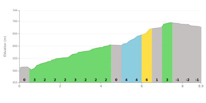
Difficulty analysis: This Category 4 climb is long (8.9 km) but not very steep (2.2% average). The difficulty lies in its unevenness: a very gentle first part, followed by a tougher section between km 5.0 and 6.5 (gradients of 5%, 4% and 3%). The final kilometer is even slightly downhill.
Tips for pacing yourself:
1. Pacing: Don't burn matches in the first 5 km, which are very manageable. Save your legs for the steeper middle section (km 5.0 to 6.5).
2. Recovering on the easy bits: Use the flat (0%) or slightly downhill sections (km 4.5-5.0 and the finale) to recover actively without easing off your cadence.
3. Approaching the summit: The final stretch isn't steep, so you can lift your pace over the last 500 metres if you still have something left in the tank.
8.9 km • 195 m D+
VAM: average climbing speed, based on elevation gain


Join thousands of cycling fans! Plan your rides, record your performance, track your progress and discover the finest climbs.
Live climb profile to pace your effort all the way to the top.


Other climbs to Mont Rigi