
Morine is a climb of 11.6 kilometers (category 1). Morine tops out at 1,253 m above sea level. It is located in Општина Невесиње / Opština Nevesinje, Република Српска / Republika Srpska, Bosna i Hercegovina / Босна и Херцеговина. The average gradient is 3.8% with a maximum of 11.6%. The climb has 445 meters of elevation gain.
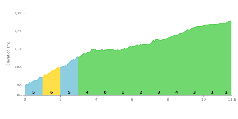
Difficulty breakdown: This climb has an unusual profile. The first half (0-5 km) is tough, with gradients of 4% to 6%, and it packs almost half of the total elevation gain. The middle section (KM 4.0-7.0) is a long false flat (0% to 2%) that gives you a welcome breather. The gradient ramps back up progressively in the final stretch (KM 7.0-9.0), with pitches of 3% to 4%.
Tips for managing your effort:
1. Start conservatively: Resist the urge to go too hard over the first 3 steep kilometres, or you'll blow up with premature lactic burn.
2. Make the most of the flat: Use the KM 4.0-7.0 section to recover actively (small gear, high cadence) and refuel.
3. Ease back into it: Get ready for the climb to steepen around KM 7.0, and build your power gradually rather than all at once.
11.6 km • 445 m D+
VAM: average climbing speed, based on elevation gain


Join thousands of cycling fans! Plan your rides, record your performance, track your progress and discover the finest climbs.
Live climb profile to pace your effort all the way to the top.

