
Vyšehorský vrch is a climb of 6.0 kilometers (category 3). Vyšehorský vrch tops out at 561 m above sea level. It is located in okres Šumperk, Střední Morava, Česko. The average gradient is 4.6% with a maximum of 9.8%. The climb has 279 meters of elevation gain.
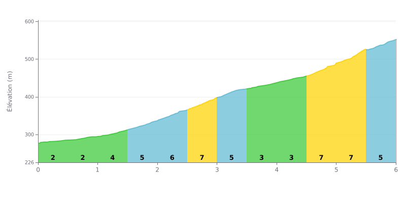
Difficulty analysis: This Category 3 climb has a tactical profile. The first half (KM 0-3) is a gradual warm-up for the legs (2% to 7%), followed by a relative breather between KM 3 and 4.5. The real difficulty is concentrated at the end, with a demanding 7% section, then 8% over the last kilometer and a half, before a final 5% stretch.
Pacing advice:
1. Save some in the tank for the end: Don't overdo it on the early gradients. The main effort comes after KM 4.5. Ride within yourself and pace accordingly.
2. Use the breather in the middle: The section between KM 3.0 and 4.5 (3-4%) is ideal for recovering, drinking and finding your rhythm again before the steep ramps.
3. Be ready for the change of rhythm: The jump from KM 4.5 (7%) to KM 5.0 (8%) is brutal. Get mentally and physically ready for that sudden intensification.
6.0 km • 279 m D+
VAM: average climbing speed, based on elevation gain


Join thousands of cycling fans! Plan your rides, record your performance, track your progress and discover the finest climbs.
Live climb profile to pace your effort all the way to the top.

