
Pohoř is a climb of 2.8 kilometers (category 3). Pohoř tops out at 471 m above sea level. It is located in okres Nový Jičín, Moravskoslezsko, Česko. The average gradient is 6.6% with a maximum of 11.2%. The climb has 184 meters of elevation gain.
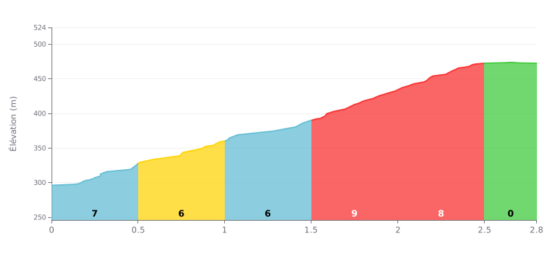
Climb difficulty analysis: This 2.8 km climb is moderately hard, typical of a Cat 3. The profile is mostly steady over the first two kilometres (gradients of 6-7%), but it gets significantly harder between 1.5 and 2.5 km with a sustained section at 9% followed by 8%, which is where most of the difficulty sits. The finish is flat (0%), giving you a breather for the final sprint.
Tips for managing your effort:
1. Save something for the middle: Don't go out too hard. Pace yourself over the first kilometres at 6-7% so you hit the steepest section (9%) with fresh legs.
2. Anticipate the change of rhythm: Around the 1.5 km mark, get ready mentally and physically for the gradient to kick up. Dropping into an easier gear just before the 9% section will help you keep your cadence up.
3. Use the flat finish: The last section at 0% is your chance to recover and open up for a sprint if you need one, without having to fight the gradient.
2.8 km • 184 m D+
VAM: average climbing speed, based on elevation gain


Join thousands of cycling fans! Plan your rides, record your performance, track your progress and discover the finest climbs.
Live climb profile to pace your effort all the way to the top.

