
Robinson Pass is a climb of 11.4 kilometers (category 1). Robinson Pass tops out at 1,733 m above sea level. It is located in Okhahlamba Local Municipality, KwaZulu-Natal, South Africa. The average gradient is 4.2% with a maximum of 13%. The climb has 481 meters of elevation gain.
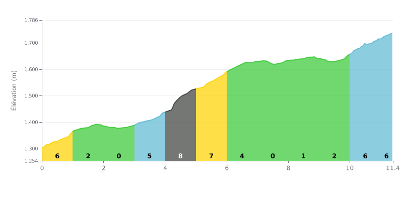
Difficulty analysis: This climb has an uneven profile, with the main difficulty concentrated between km 4 and 6 (gradients of 10% and 7%). The km at 10% is the most demanding. The flat or gentler sections (KM 2-3 and 7-9) offer chances to recover, but the finish (KM 10-11.4) ramps back up to 6%.
Pacing advice:
1. Dial in your effort for the 10% km (KM 4-5): Use an easy gear so you don't blow up, and save your legs for what's left.
2. Make the less steep sections count (KM 1-3 and 7-9): recover by spinning without forcing, while keeping a steady rhythm.
3. Save something for the last 2 km (6% gradient), which demand a fresh surge of sustained effort after an easier stretch.
For cyclists who have climbed the Col Robinson, the experience is first and foremost marked by breathtaking views. Riders describe the vistas over the valleys and mountains as "spectacular" and "mind-blowing," with plenty of spots to pull over and soak up the panorama.
The climb itself is described as a real challenge, especially on a mountain bike, which one rider called "agony." On the other hand, the road surface, though "not the smoothest," is considered good enough to let you enjoy the bends for those who love the grind and the technical side of things.
The experience isn't without its downsides. Some riders point to litter along the roadside, especially around the picnic areas, which takes away from the beauty of the place.
Still, the overall feeling is one of a unique, unforgettable ride. Riders talk about a "magnificent and mesmerizing" stretch, at times "scary" but "incredible," and many say it's a "must-do" they'd happily ride again.
11.4 km • 481 m D+
VAM: average climbing speed, based on elevation gain


Join thousands of cycling fans! Plan your rides, record your performance, track your progress and discover the finest climbs.
Live climb profile to pace your effort all the way to the top.

