
Kotagiri is a climb of 29.0 kilometers (hors catégorie). Kotagiri tops out at 1,955 m above sea level. It is located in Odanthurai, Tamil Nadu, India. The average gradient is 6.7% with a maximum of 12.8%. The climb has 1934 meters of elevation gain.
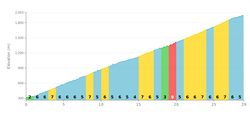
Difficulty breakdown: Beyond category climb, 29 km long and seriously hard. The average gradient of 7% is steady, with very little respite. The 9% sections (KM 19-20) and the many 7% stretches (KM 26-27, 23-24, 15-16) are the real crux here, so you need to manage your effort carefully.
Pacing tips:
1. Set your rhythm from the start: The first 5 km (2-7%) let you ease into it. Don't go over the limit on those "easy" gradients or you'll burn matches you'll need later.
2. Anticipate the steep spots: Mentally mark the steepest kilometres (e.g. KM 19-20 at 9%). Ease off the pace a touch before them so you hit them with fresh legs.
3. Use the 4-5% sections: KM 14-15 (4%) and KM 17-19 (3-5%) are short breathers. Take advantage to get back into a rhythm, drink and eat without blowing your cadence.
29.0 km • 1934 m D+
VAM: average climbing speed, based on elevation gain


Join thousands of cycling fans! Plan your rides, record your performance, track your progress and discover the finest climbs.
Live climb profile to pace your effort all the way to the top.

