
Umling La Road highest point is a climb of 22.0 kilometers (hors catégorie). The climb finishes at 5,790 m above sea level. It is located in Nyoma, Ladakh, India. The average gradient is 5.1% with a maximum of 13.4%. The climb has 1115 meters of elevation gain.
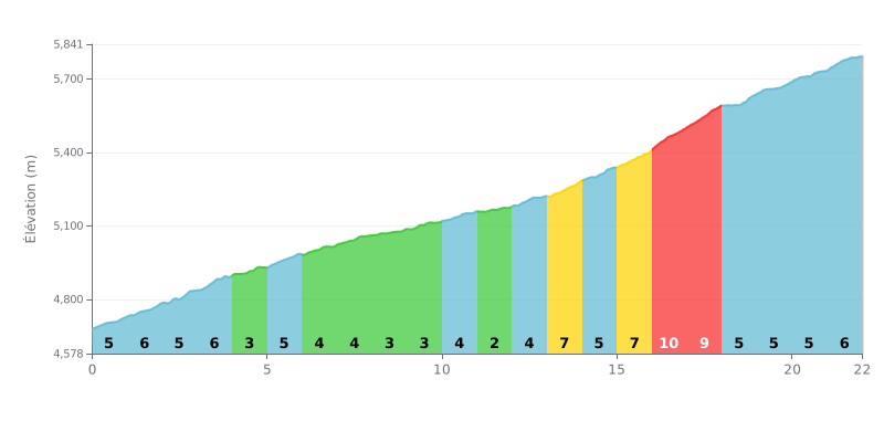
Difficulty analysis: This hors catégorie climb covers 22 km for 1115 m of elevation gain, with an average gradient of 5.1%, which makes it a long, steady ascent. The first four kilometres, between 5% and 6%, demand a strong pace, then kilometres 4 to 10 offer easier stretches at 3 or 4%. The real difficulty is concentrated between kilometres 13 and 18, where the gradient hits 7% and then 9% over kilometres 16 to 18, before a finish at 5-6%.
Pacing tips:
1. Pace yourself from the bottom. Over kilometres 0 to 4, at 5-6%, hold a steady cadence so you reach the foot of the steepest section with some in the tank.
2. Make the most of the 2% section from kilometre 11 to 12. This is the only truly rolling stretch of the climb: recover, drink and eat.
3. Prepare for the decisive block between kilometres 16 and 18. Shift to a lighter gear, stay in the saddle and favour a smooth cadence rather than mashing the pedals.
Those who have ridden up to Umling La talk about the altitude first. The pass is signposted at 19,024 feet, roughly 5,800 m, and several say it is higher than the Everest base camp. Almost everyone advises acclimatising well before you go. Some got headaches or dizziness, and one rider noted that the air gets thin very quickly.
The road comes up often in the reports. Many find it smooth and well maintained, and they give credit to the BRO. But the route changes depending on which way you go. Via Hanle and Photi La, the tarmac is sometimes narrow, with sheer drop-offs, and one rider reckons a car will struggle on the last part of the Nerbole Top steep section. Via the Nurbu La track, you're riding on dirt, with small posts marked "ZSR" to follow the way, because the maps don't work well in the area. One rider came back via Chisumle, which was gravel the whole way. People also report possible snow and rain in the afternoon, with sub-zero temperatures.
Time spent at the top comes up in almost every account. Several people advise not staying more than 10 to 20 minutes. One rider says the oxygen is only about 50% of what you get at sea level, and another talks about nosebleeds and disorientation in people who were otherwise well acclimatised. Others stayed longer without any problems. The most repeated advice is to bring a bottle of oxygen, climb slowly and breathe slowly through your nose.
As for services, don't expect much. There's a small café run by the army and toilets run by the BRO and the army, but one rider found them closed, and another says they mainly open when VIPs arrive. The oxygen bar wasn't open to visitors. There's no phone signal, and according to several people there's no fuel available after Hanle. So bring water, food and petrol. For the Hanle, Tso Moriri and Pangong area, a permit may be required, and a Korean woman explains that foreigners can't always stay in Hanle, which complicates planning the trip.
As for the atmosphere, riders describe a deep silence, a very blue sky and a very strong sun when the weather is good. The wind is strong, it feels bitterly cold, and prayer flags flutter at the summit. Almost all the reports come from motorbikes, cars or Thars, and none describes a climb on a bike. Those who did it, solo or in a group, are proud to have reached the top, but their bodies take a real beating.
22.0 km • 1115 m D+
VAM: average climbing speed, based on elevation gain


Join thousands of cycling fans! Plan your rides, record your performance, track your progress and discover the finest climbs.
Live climb profile to pace your effort all the way to the top.

