
Naltar Valley is a climb of 15.9 kilometers (hors catégorie). Naltar Valley tops out at 2,877 m above sea level. It is located in Nomal, گلگت بلتستان, پاکستان. The average gradient is 9.4% with a maximum of 18.3%. The climb has 1487 meters of elevation gain.
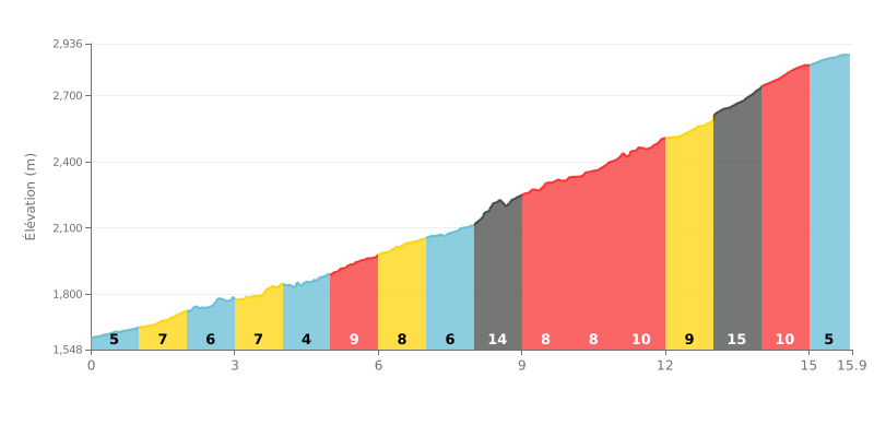
Difficulty breakdown: This HC climb covers 15.9 km at an average gradient of 9.4%, which makes it a serious test. The real pain is in the middle and the final third, with two very steep kilometres: KM 8-9 at 14% and KM 13-14 at 15%. The gradient stays above 8% from km 5 to km 14, and there's no real respite anywhere in that stretch.
How to manage the effort:
1. Pacing: Start easy on the opening kilometres (4-7%) and save your legs for the tough section from km 5 to km 14.
2. Prepare for the key sections: Shift down before the two steepest sections (around km 8 and km 13) so you can keep a smooth, steady cadence and avoid blowing up your legs.
3. Steady effort: On the long stretches at 9%, find a sustainable rhythm you can hold without surging, and save something extra for the finale (km 14-15 at 10%).
15.9 km • 1487 m D+
VAM: average climbing speed, based on elevation gain


Join thousands of cycling fans! Plan your rides, record your performance, track your progress and discover the finest climbs.
Live climb profile to pace your effort all the way to the top.

