
Núi Phja Oắc is a climb of 19.2 kilometers (hors catégorie). The climb finishes at 1,916 m above sea level. It is located in Nguyên Bình, Tỉnh Cao Bằng, Việt Nam. The average gradient is 8.9% with a maximum of 19.7%. The climb has 1717 meters of elevation gain.
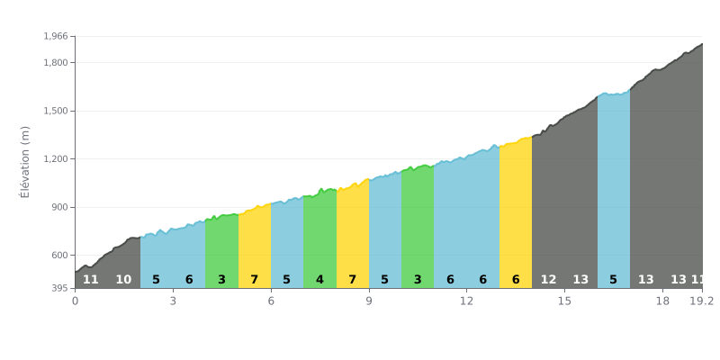
Difficulty breakdown: At 19.2 km, with 1717 m of elevation gain and an average gradient of 8.9%, the Núi Phja Oắc from Pac Bó is clearly a hors catégorie climb. The start is tough right away, with 11% over km 0-1 followed by 10% over km 1-2. Between km 2 and 5, the gradient bounces between 3% and 6%, which gives you some relative respite before the hardest sections. The real difficulties come next, at km 14-16 (12% then 13%), and above all in the final stretch from km 17 to km 19.2, with sections at 13%, 13% and 11%.
Tips for managing your effort:
1. Don't go out too hard. The first two kilometres at 11% and 10% tempt you to attack, but hold a controlled cadence so you reach the next section with something left in the tank.
2. Recover between km 2 and 5. Use the 3% to 6% stretches to spin your legs, eat and drink, so you tackle the km 14-16 section with reserves.
3. Save something for the finish. The last third, from km 17 to km 19.2, is the steepest part of the climb: keep some energy in reserve and a gear ratio low enough to keep your cadence up all the way to the top.
Phia Oắc Pass can be climbed from Provincial Route 212, or from Cao Bằng city. It has about 5 km of concrete road winding through the forest. Several riders report sections at 18%, tight switchbacks and narrow stretches. Those who came up from Bắc Kạn say the road is more broken up than the one from Cao Bằng, and one of them found subsidence on the last section, which was under repair.
The climb is open to cars and motorbikes. There's a barrier at the bottom: you can just slip past it, or ask at the forest ranger station across from the road. When moss, fog or frost covers the surface, the tarmac gets slick, and riders advise taking it easy and spinning a small gear. One report also mentions motorbikes struggling on the descent because of the fog.
At the top, the landscape is low forest covered in moss, with abandoned buildings that some say date from the French colonial era. The 75 m radio transmitter tower dominates the viewpoint. When the sky is clear, the view stretches a long way and, at certain times of year, a sea of clouds spreads out below the summit. But fog is common, and some riders have waited two hours without seeing a thing before the clouds lifted. As for facilities, there are no benches, bins or toilets, and rubbish piles up in the car park.
It's cold almost all year round: one rider noted around 15 °C at the top in the middle of summer, and the wind is strong. Frost and snow show up in winter. There's no petrol station and no restaurant, so it's best to bring food and water. Several people mention dogs at the summit, and some advise bringing food for them. Another report, on the contrary, describes aggressive dogs at the entrance. Finally, one single rider mentions safety incidents in the area and advises checking your brakes before heading back down. It's an isolated account, so take it with caution.
19.2 km • 1717 m D+
VAM: average climbing speed, based on elevation gain


Join thousands of cycling fans! Plan your rides, record your performance, track your progress and discover the finest climbs.
Live climb profile to pace your effort all the way to the top.

