
Chang La is a climb of 6.9 kilometers (category 1). The climb finishes at 4,713 m above sea level. It is located in Ngari, 西藏自治区 བོད་རང་སྐྱོང་ལྗོངས།, 中国. The average gradient is 5.2% with a maximum of 12.3%. The climb has 357 meters of elevation gain.
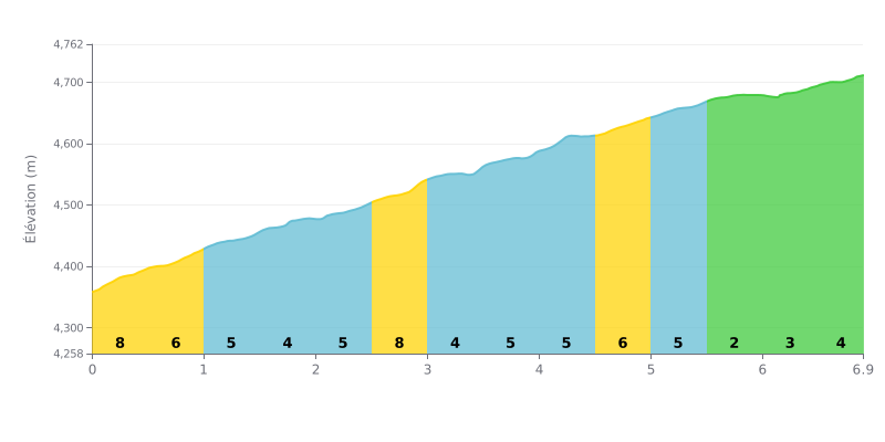
Difficulty breakdown: The Chang La from Koyül covers 6.9 km for 357 m of elevation gain, with an average gradient of 5.2%, which puts it in Category 1. The real challenge is the consistency: nearly every section sits between 4% and 8%, with no real chance to recover. The steepest stretch is at KM 0.0-0.5 at 8%, and KM 2.5-3.0 at 7% is the most demanding part of the middle section. Only KM 5.5-6.0, at 2%, gives you a proper breather before the finale.
Tips for managing your effort:
1. Pacing the start Don't go out too hard over KM 0.0-0.5 at 8%. It's tempting to hammer it when there's still a long way to go.
2. Riding at a steady effort On the 5 and 6% sections, pick a gear that lets you keep a smooth, steady cadence rather than burning through your reserves.
3. Making the most of the flat Recover properly over KM 5.5-6.0 at 2%, taking on food and fluids before the last kilometres at 4%.
6.9 km • 357 m D+
VAM: average climbing speed, based on elevation gain


Join thousands of cycling fans! Plan your rides, record your performance, track your progress and discover the finest climbs.
Live climb profile to pace your effort all the way to the top.

