
Taldok Pass is a climb of 21.9 kilometers (hors catégorie). Taldok Pass tops out at 3,575 m above sea level. It is located in n/a, Ош облусу, Кыргызстан. The average gradient is 4.9% with a maximum of 14.4%. The climb has 1063 meters of elevation gain.
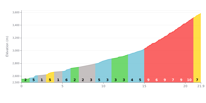
Difficulty breakdown: This 21.9 km climb has two distinct sections. The first 14 km (average gradient of 3.4%) is a demanding warm-up. The real challenge, rated HC, is concentrated in the final 7 km, with sustained gradients between 7% and 9%, accounting for nearly half of the total climbing (455m out of 1063m).
Pacing advice:
1. Managing your pace: Ride the first section in endurance mode to save your legs. The real effort starts at KM 15.
2. Anticipating the change of rhythm: From KM 15, shift to a easier gear and adjust your cadence to hold a steady power output on the steep sections.
3. Breaking the climb down mentally: Treat the final 7 km as a climb in its own right to stay focused.
For cyclists heading up the Taldok Pass, the climb is first and foremost a encounter with history. Riders' accounts recall that this road, built in the 1930s and rebuilt a decade ago, is a major artery, open year-round, linking Kyrgyzstan to Tajikistan. At the summit, at 3,615 meters above sea level, a monument honors the builders, adding a solemn note to the effort.
The climb is often described as a challenge that is both physical and sensory. The road, called "serpentine" for its many switchbacks, winds up through changing conditions, where the weather at the top can be radically different from what you left in the valley. Traffic isn't described as heavy, but riders have to share the tarmac with other travelers, motorcyclists and drivers.
What really sticks with people is the raw beauty of the scenery. Riders talk about "superb views" and "coucou-nüß inoubliables," with the chance to spot iconic peaks like Lenin Peak in the distance. The summit has a special vibe: an informal meeting spot where you often run into other bike adventurers, in an atmosphere that is often windy and cold, even in July.
The descent, though exhilarating, demands extra caution. Some accounts mention road surfaces that can be "really rough" or worn, which makes riding tricky, especially if the pavement is wet. There are no services on the pass itself, so plan your resupply in the villages down below.
21.9 km • 1063 m D+
VAM: average climbing speed, based on elevation gain


Join thousands of cycling fans! Plan your rides, record your performance, track your progress and discover the finest climbs.
Live climb profile to pace your effort all the way to the top.

