
La Uvita is a climb of 24.8 kilometers (hors catégorie). La Uvita tops out at 2,858 m above sea level. It is located in n/a, Boyacá, Colombia. The average gradient is 7.1% with a maximum of 14.3%. The climb has 1770 meters of elevation gain.
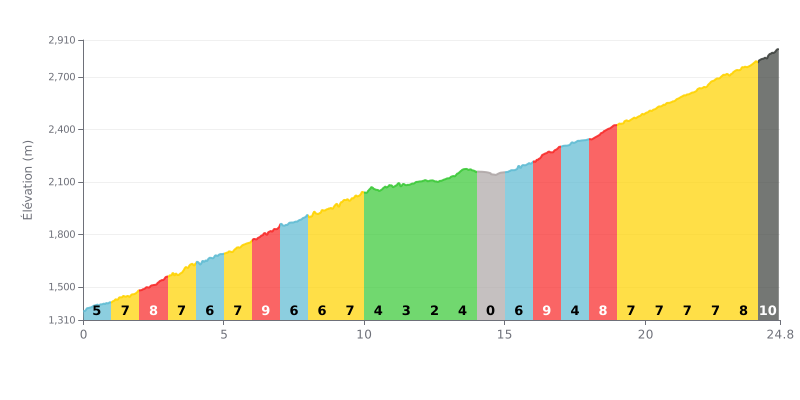
Difficulty breakdown: This HC climb is 24.8 km long with 1770m of elevation gain, so it's a serious undertaking on length alone. The average gradient of 7.1% is sustained, but the real difficulty lies in the variations: a flatter section between km 12 and 15 (0-4%) gives you a bit of respite, while the 9-10% stretches (km 6-7, km 16-17 and the finale) demand real grinding.
How to manage the effort:
1. Pace yourself over the first half: Use km 10 to 15, where the gradient eases (2-4%), to recover and dial in your pace before the harder sections that follow.
2. Save something for the steep ramps: Keep some reserves for the three key 9% sections and the 10% finale over 800m, which will be decisive for your time.
3. Manage your gearing: The changing gradients call for careful gear selection to maintain a steady cadence and avoid blowing up on the steeper pitches.
24.8 km • 1770 m D+
VAM: average climbing speed, based on elevation gain


Join thousands of cycling fans! Plan your rides, record your performance, track your progress and discover the finest climbs.
Live climb profile to pace your effort all the way to the top.

