
La Cienega is a climb of 11.5 kilometers (hors catégorie). La Cienega tops out at 1,570 m above sea level. It is located in n/a, Nuevo León, México. The average gradient is 10.0% with a maximum of 17%. The climb has 1151 meters of elevation gain.
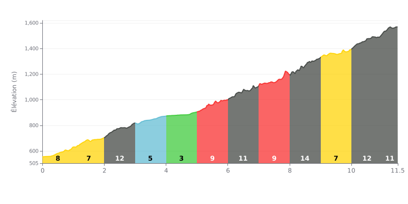
Climb analysis: This 11.5 km climb has an average gradient of a demanding 10%, but the real difficulty lies in the uneven profile. KM 2-3 (11%), KM 6-7 (12%), KM 8-9 (14%) and KM 10-11 (12%) are the key sections that break your rhythm, while KM 4-5 (3%) gives you a brief breather.
Tips for managing your effort:
1. Pace yourself section by section: Plan for the 12-14% stretches (KM 6-7, 8-9 and 10-11) and ease off a bit on the flatter parts to save your legs.
2. Make the most of KM 4-5 (3%): Use this section to recover (spin easy) and mentally prepare for the hard stretches coming up.
3. Keep a steady cadence: Avoid surging on the steep ramps. Running a gear that lets you hold a smooth, consistent cadence is key to saving energy.
11.5 km • 1151 m D+
VAM: average climbing speed, based on elevation gain


Join thousands of cycling fans! Plan your rides, record your performance, track your progress and discover the finest climbs.
Live climb profile to pace your effort all the way to the top.

