
Col du Maquisard is a climb of 8.1 kilometers (category 3). Col du Maquisard tops out at 368 m above sea level. It is located in n/a, Liège, België / Belgique / Belgien. The average gradient is 3.4% with a maximum of 8.4%. The climb has 274 meters of elevation gain.
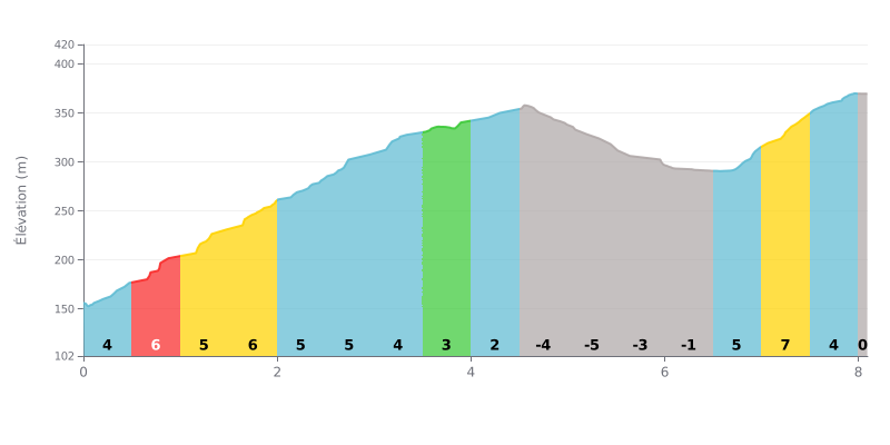
Difficulty analysis: This Category 3 climb has an atypical profile. The first section (0-4 km) is a consistently uphill drag averaging 5-6%, followed by a long descent of nearly 3 km. The real difficulty lies in the demanding finish, with a 7% ramp over the last kilometre after a recovery section.
Pacing advice:
1. Managing changes of pace: Don't go hard on the descent (KM 4.5-6.5). Spin the legs over actively to recover ahead of the finale.
2. Planning for the finish: Take on the last 2 km (KM 6.5-8.1) with something left in the tank, as the gradient jumps from 5% to 7% over a short but intense stretch.
3. Steady rhythm from the bottom: Hold a constant power output over the first 4 km to avoid blowing up before the recovery section.
For cyclists, the Col du Maquisard is much more than just a climb. It's first and foremost a climb into history, a peaceful, well-kept memorial dedicated to the Resistance fighters of World War II, with a particular atmosphere of reflection.
Riders describe an ideal starting point for a ride, with easy parking and good options for walks in the forest, especially gentle hikes without much climbing or mushroom picking.
While the spot is appreciated for its calm and pleasant setting, some riders who shared their experience point out that the surroundings can feel a bit lacking in things to see, to the point that others regard it as a place to visit mainly "on the Durchfahrt", just passing through.
Finally, riders' experiences suggest that the trail signage could be improved to make exploring easier. Also, some have run into difficult weather, describing a feeling of "cold and dampness" on site.
8.1 km • 274 m D+
VAM: average climbing speed, based on elevation gain


Join thousands of cycling fans! Plan your rides, record your performance, track your progress and discover the finest climbs.
Live climb profile to pace your effort all the way to the top.


Within 20 km