
Chilla is a climb of 40.0 kilometers (hors catégorie). Chilla tops out at 2,478 m above sea level. It is located in n/a, Jammu and Kashmir, India. The average gradient is 5.6% with a maximum of 12.4%. The climb has 2221 meters of elevation gain.
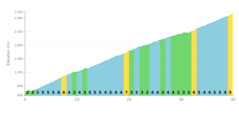
Difficulty analysis: This climb is 40 km long with 2221 m of elevation gain and a demanding average gradient of 5.6%. The difficulty lies in its length and the variability of the gradients, with several stretches at 6-7% (km 6-8, km 19, km 32) that break the rhythm and require disciplined pacing.
Pacing tips:
1. Settle into a steady rhythm by targeting an effort level that matches the 5.6% average gradient. Avoid going over your limit on the 7% sections to save energy for the long haul.
2. Make the most of the easier sections (km 9-10, km 20, km 29, km 31) to recover actively by keeping a smooth, relaxed spin without forcing it.
3. Anticipate the gradient changes, especially the tough km 32 section (7% over 833 m) after a flat stretch, so you can shift to a easier gear and adjust your effort in time.
40.0 km • 2221 m D+
VAM: average climbing speed, based on elevation gain


Join thousands of cycling fans! Plan your rides, record your performance, track your progress and discover the finest climbs.
Live climb profile to pace your effort all the way to the top.

