
Chemin des Mazures is a climb of 2.6 kilometers (category 2). Chemin des Mazures tops out at 465 m above sea level. It is located in n/a, Liège, België / Belgique / Belgien. The average gradient is 8.1% with a maximum of 16.2%. The climb has 210 meters of elevation gain.
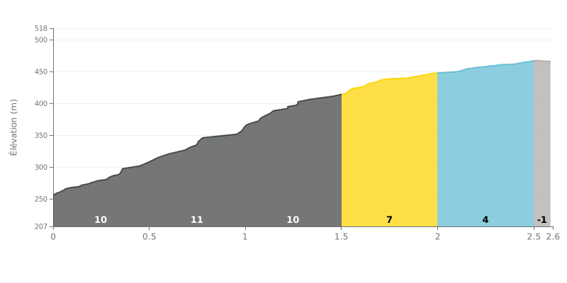
Difficulty breakdown: This 2.6 km climb is short but brutal. The real pain is concentrated in the first 1.5 km, with savage 10-11% ramps. The final kilometre, at a more forgiving 4-6%, gives you a bit of breathing room for the finish. With 210m of elevation gain at an average gradient of 8%, it's rightly rated as a Cat 2 climb.
How to pace it:
1. Start controlled: Don't go out too hard in the first 500 metres at 11%. Settle into a steady rhythm and save your legs for later.
2. Managing the easing: After 1.5 km, the gradient drops noticeably (6%, then 4%). Use this section to recover by easing off the power a touch while keeping your cadence up.
3. Hold a steady effort: Find a level of effort (power or heart rate) you can sustain on the 11% sections. It will feel easier on the flatter parts.
2.6 km • 210 m D+
VAM: average climbing speed, based on elevation gain


Join thousands of cycling fans! Plan your rides, record your performance, track your progress and discover the finest climbs.
Live climb profile to pace your effort all the way to the top.


Within 20 km