
Alto de Tepecoyo is a climb of 9.6 kilometers (hors catégorie). Alto de Tepecoyo tops out at 1,230 m above sea level. It is located in n/a, La Libertad, El Salvador. The average gradient is 8.1% with a maximum of 20.4%. The climb has 777 meters of elevation gain.
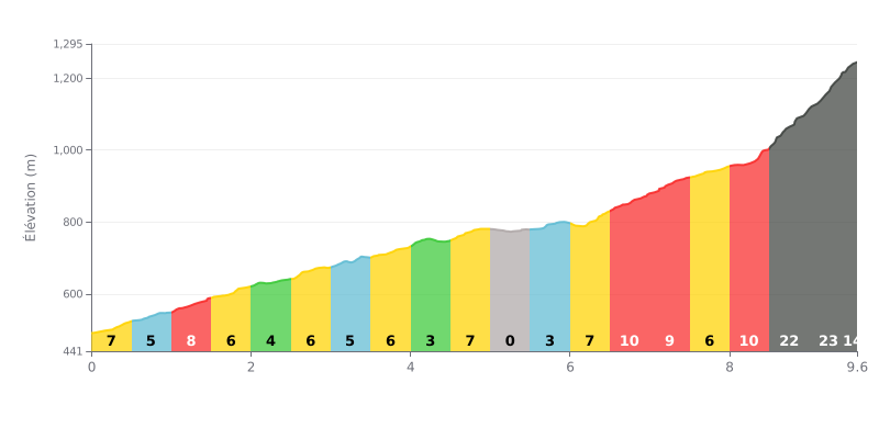
Difficulty breakdown: This beyond category climb has its major difficulty in the final third. The 9.6 km averaging 8% are deceptive: the first half is relatively moderate (gradients of 3% to 8%), but the finish is brutal, with two kilometres at over 22%. That final section is what makes this climb exceptionally hard.
Pacing advice:
1. Managing your pace on the first part: Make the most of the easier sections (KM 2.0-2.5 at 4%, KM 4.0-4.5 at 3%, KM 5.0-5.5 at 0%) to recover and avoid going out too hard. The real effort starts after KM 6.
2. Saving something for the decisive finish: Look ahead to the final test (KM 8.5-9.5). Keep some energy in reserve on the 9-10% stretch (KM 6.5-8.0) so you can tackle the 22-23% ramps with a suitable gear and a smooth cadence.
9.6 km • 777 m D+
VAM: average climbing speed, based on elevation gain


Join thousands of cycling fans! Plan your rides, record your performance, track your progress and discover the finest climbs.
Live climb profile to pace your effort all the way to the top.


Other climbs to Alto de Tepecoyo