
Predná hora is a climb of 4.4 kilometers (category 1). The climb finishes at 761 m above sea level. It is located in Muráň, Banskobystrický kraj, Slovensko. The average gradient is 7.7% with a maximum of 10%. The climb has 342 meters of elevation gain.
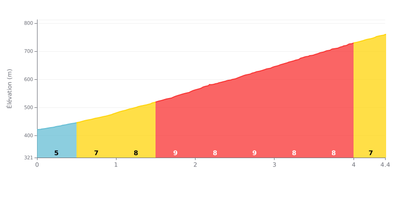
Difficulty breakdown: At 4.4 km for 342 m of elevation gain and an average gradient of 7.7%, the Predná hora from Muráň is a tough, steady Category 1 climb. The profile is very consistent: after a 5% start on KM 0.0-0.5, the gradient settles between 7% and 9% for almost the entire climb. The KM 1.5-2.0, KM 2.5-3.0 and KM 3.5-4.0 sections each hit 9%, so you'll be working hard from bottom to top.
Tips for pacing the climb:
1. Pacing the start. KM 0.0-0.5, at 5%, is the easiest section: use it to find a steady rhythm without blowing up.
2. Staying smooth on the 9% sections. On KM 1.5-2.0, 2.5-3.0 and 3.5-4.0, pick a gear you can comfortably spin and keep a smooth cadence to save your legs.
3. Save something for the finish. KM 4.0-4.4, at 7%, is still demanding: keep some energy in reserve so you can finish strong after kilometres at 8% and 9%.
Reviews of Predná Hora are mostly about the place itself: a spa facility, guesthouses and chalets in the middle of nature. The climb itself is hardly ever described, and only one person mentions cycling among the things to do there.
What comes up most is the setting. People talk about a quiet spot, a nice park and meadows. One visitor points out a walking route to a meadow with susliks, and another mentions hiking trails in the surroundings. The castle isn't open to visitors, so you can only stroll around the park.
The clearest negative concerns the road. One review describes a section that's been destroyed and closed to traffic, which you have to walk at your own risk, and estimates the works will take at least two years. Another visitor simply calls the route horrible, with no further detail. On the food side, one visitor finds the prices high and mentions a mix-up with an order.
Apart from that, the reviews are short and mostly say "beautiful", "quiet" or "pleasant". Nothing tells you the length, the gradient or the condition of the climb itself.
4.4 km • 342 m D+
VAM: average climbing speed, based on elevation gain


Join thousands of cycling fans! Plan your rides, record your performance, track your progress and discover the finest climbs.
Live climb profile to pace your effort all the way to the top.

