
Cerro Phajra Phajra is a climb of 6.6 kilometers (category 2). The climb finishes at 3,917 m above sea level. It is located in Municipio Yocalla, Potosí, Bolivia. The average gradient is 4.6% with a maximum of 16.7%. The climb has 305 meters of elevation gain.
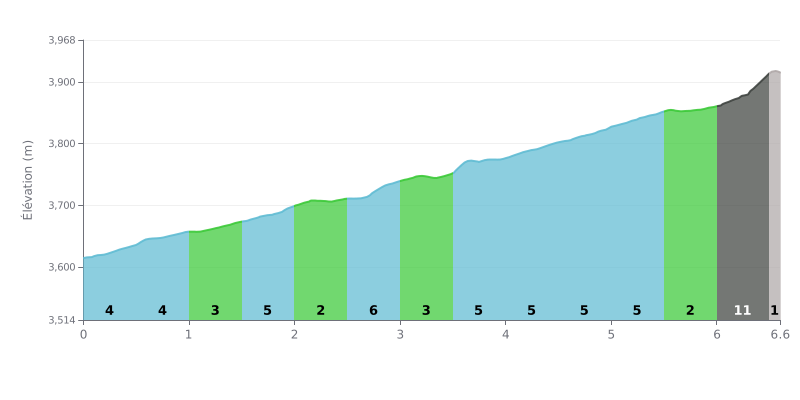
Difficulty analysis: Over 6.6 km for 305 m of elevation gain, the Cerro Phajra Phajra from San Antonio averages 4.6%, which makes it a demanding and steady climb. Most of the route sits between 3% and 5%, with a few harder sections, such as the 2.5-3.0 km stretch at 6%. The real test comes between km 6.0 and 6.5, where the gradient hits 11% over 56 m of climbing, just when your legs are already well cooked.
Tips for the effort:
1. Pace yourself on the first kilometres. Between 0.0 and 2.0 km, at an average of 4%, settle into a steady rhythm and don't go past your limit.
2. Make the most of the false flat. Between 2.0 and 2.5 km, the gradient drops to 2%: this is the perfect moment to recover, drink, and get your cadence back up.
3. Save something for the finish. Tackle the 6.0-6.5 km section at 11% with a light gear and a high cadence, staying seated to conserve your energy.
6.6 km • 305 m D+
VAM: average climbing speed, based on elevation gain


Join thousands of cycling fans! Plan your rides, record your performance, track your progress and discover the finest climbs.
Live climb profile to pace your effort all the way to the top.


Other climbs to Cerro Phajra Phajra