
Cerro el Amago is a climb of 17.1 kilometers (hors catégorie). Cerro el Amago tops out at 1,738 m above sea level. It is located in Municipio de San Francisco del Monte de Oro, San Luis, Argentina. The average gradient is 5.5% with a maximum of 16%. The climb has 946 meters of elevation gain.
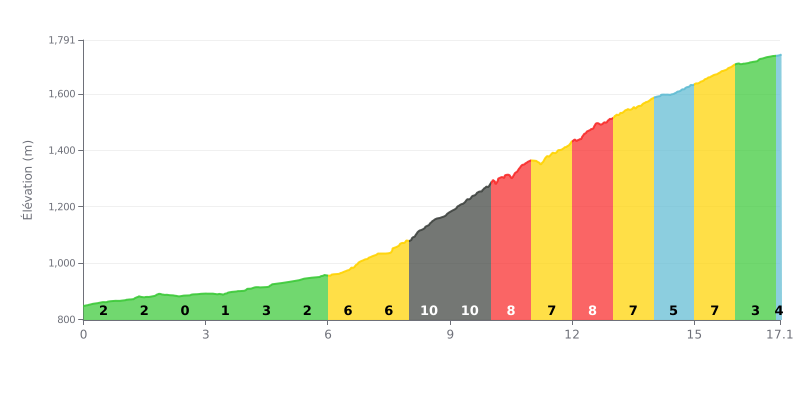
Difficulty breakdown: This climb has two distinct phases. The first 6 KM (average gradient 1-3%) is a deceptive warm-up. The real difficulty starts at KM 6 with a 7% gradient, peaking over 4 KM (KM 8 to 12) with brutal sections of 8% to 10%. The second half stays tough (5-8% gradients) before an easier finish.
Pacing advice:
1. Keep something in the tank early on: Resist the urge to go hard on the first flatter kilometres. Use them to settle into a steady breathing rhythm and save your legs for the middle section.
2. Prepare for the KM 8-12 wall: Before tackling the steepest section (10%), consider shifting to an easier gear. The goal is to keep a smooth, steady cadence without blowing up.
3. Manage the finish mentally: Even though the gradient eases after KM 14, accumulated fatigue will make the final percentages feel hard. Stay focused all the way to the summit.
For cyclists looking for an authentic mountain experience, the climb up Cerro El Amago is described as a near must-do. Riders agree on its breathtaking beauty: a spectacular panoramic view over the valley, Dique Las Palmeras and the village of San Francisco del Monte de Oro opens up from viewpoints placed just right.
The climb is genuinely hard, and riders are quick to point this out: Provincial Route 9 is a demanding cornice road, with a series of very tight bends and a steep gradient, especially from San Francisco. The surface is generally good (asphalt), but it remains narrow, demanding constant vigilance. Some riders mention fast-moving vehicles and the need to be extra careful.
What makes this climb unique, beyond the challenge, is the total immersion in nature and the chance to see majestic wildlife. Many riders report the unforgettable thrill of watching condors glide at impressively close range, sometimes perched on the antennas at the summit, around 1700 meters above sea level.
The ride is therefore reserved for well-prepared cyclists, with a bike in good condition (brakes are crucial) and a healthy dose of caution. But for those who have done it, the effort is more than rewarded by grandiose scenery and a sense of accomplishment that stays with you. As the testimonies say, it is an impressive route and 100% recommended.
17.1 km • 946 m D+
VAM: average climbing speed, based on elevation gain


Join thousands of cycling fans! Plan your rides, record your performance, track your progress and discover the finest climbs.
Live climb profile to pace your effort all the way to the top.

