
Paso Sico is a climb of 14.6 kilometers (category 4). Paso Sico tops out at 4,148 m above sea level. It is located in Municipio de San Antonio de los Cobres, Salta, Argentina. The average gradient is 2.3% with a maximum of 5.2%. The climb has 332 meters of elevation gain.
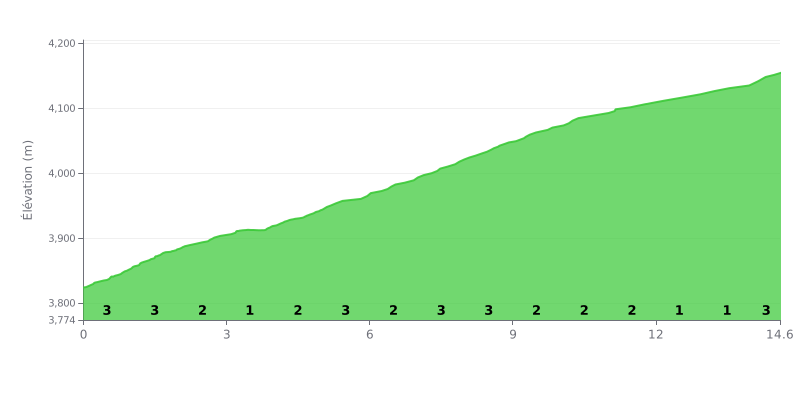
Difficulty breakdown: This 4th category climb is long (14.6 km) but has a very gentle average gradient (2.3%). The difficulty lies in its consistency, with a succession of 2-3% sections and no real respite. The total elevation gain is modest (332m), which makes it a climb suitable for riders of all levels, but its length demands disciplined pacing.
Tips for managing your effort:
1. Pace yourself: Don't go out too hard. Keep a high cadence (80-90 rpm) on the 3% sections to save your legs.
2. Make the most of the flat bits: Use the short 1% sections (KM 3-4 and KM 12-13) to recover actively by easing off the intensity without slowing down.
3. Save something for the finish: The final stretch (KM 14-14.6) averages 3%. Keep some energy in reserve for that last push before the summit.
For cyclists seeking pure adventure, the Paso de Sico leaves a lasting impression. Riders describe breathtaking scenery, with lagoons, salars and volcanoes, in a mineral immensity that gives the feeling of "connection with the sky". The beauty of the place is so striking that it is consistently cited as the ultimate reward.
This climb is, however, not for beginners. Riders face a dirt and rock road on the Argentine side, about 130 km long, with rough sections, "serrucho" and numerous "panelões". On top of that come extreme weather conditions: strong, steady wind, dust, and temperatures that can drop below zero, so careful preparation is essential.
One crucial point comes up again and again in riders' accounts: this border crossing is closed to tourists and reserved for trucks. Several cyclists had to turn back after a long approach and were forced to reroute to the Paso de Jama. It is therefore imperative to check officially before attempting the pass.
Despite the isolation and the lack of infrastructure (no gas stations or SOS points), riders stress the warm assistance of the border guards on both the Argentine and Chilean sides, who can offer drinking water, a place to sleep for the night, or valuable help if needed.
Riding the Paso de Sico means committing to a demanding and unforgettable adventure, reserved for experienced, well-equipped cyclists ready to accept the unexpected in exchange for an experience off the beaten track, in the heart of vast and pristine landscapes.
14.6 km • 332 m D+
VAM: average climbing speed, based on elevation gain


Join thousands of cycling fans! Plan your rides, record your performance, track your progress and discover the finest climbs.
Live climb profile to pace your effort all the way to the top.

