
Filo Sierras Comechingones is a climb of 14.3 kilometers (hors catégorie). Filo Sierras Comechingones tops out at 2,108 m above sea level. It is located in Municipio de Merlo, San Luis, Argentina. The average gradient is 9.4% with a maximum of 18.6%. The climb has 1347 meters of elevation gain.
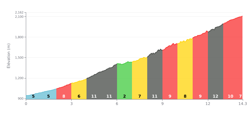
Difficulty analysis: This HC climb is hard because of its length (14.3 km) and its high average gradient (9.4%). The difficulty is compounded by a series of demanding sections, notably two kilometres at 11% (KM 4-6) and a brutal finish with 12% gradients at the 12th kilometre.
How to manage the effort:
1. Set your pace from the start: The first kilometres (5-8%) are more manageable. Use them to find a sustainable tempo without blowing up.
2. Save something for the key sections: Keep some energy in reserve for the two kilometres at 11% (KM 4-6) and the 12% ramp at KM 12. Ease off a touch on the 3% recovery kilometre (KM 6-7).
3. Manage the finish: The gradient stays steep (8-9%) over the final kilometre. Keep a steady cadence all the way to the summit.
Riders who have climbed El Filo Merlo describe an epic experience, a winding ascent that tops 2,000 meters of elevation. The road, fully paved on the San Luis side, snakes along the mountainside, offering increasingly impressive panoramic views of the town of Merlo and the Conlara Valley with every bend. For many, just grinding up this well-kept mountainside road is an adventure in itself.
The climb is genuinely tough, especially in the last few kilometers where the gradient really bites. Riders stress the importance of being well prepared and of managing your effort, maybe splitting the climb into two sections with a stop at the Mirador del Sol. The total climbing is substantial, but the generally good road surface lets you focus on your effort and the scenery. The descent demands real caution: everyone agrees you absolutely have to use your gears to control your speed (on the way down, ride in second gear) to avoid overheating your brakes, a common risk on this route.
Once you reach the "Filo," the view matches the effort you put in. Riders are rewarded with a breathtaking view and a feeling of being on top of the world, with San Luis province on one side and, on a clear day, the landscapes of Córdoba on the other. It's a spot made for taking it all in, perfect for a well-earned break with a mate while watching the condors soar. Some riders mention small local shops where you can buy regional products.
This climb comes with its challenges. Riders report that you need to stay alert to car and motorcycle traffic on the road. Altitude also brings sudden temperature changes, so pack an extra layer: it can get very cold and windy at the top, even when it's hot down in the valley. Still, everyone agrees this ride is unforgettable, a must-do for any cyclist visiting the region.
14.3 km • 1347 m D+
VAM: average climbing speed, based on elevation gain


Join thousands of cycling fans! Plan your rides, record your performance, track your progress and discover the finest climbs.
Live climb profile to pace your effort all the way to the top.

