
Volcan de Agua is a climb of 34.0 kilometers (hors catégorie). Volcan de Agua tops out at 1,534 m above sea level. It is located in Municipio de Escuintla, Escuintla, Guatemala. The average gradient is 4.0% with a maximum of 13.3%. The climb has 1371 meters of elevation gain.
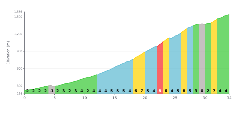
Difficulty analysis: This 34 km climb has a demanding profile that gets harder as it goes. The first 15 km (average gradient of 2-3%) serve as a warm-up before things ramp up noticeably. The toughest section is between km 18 and km 27, with a series of 7% and 8% pitches, notably at KM 22.0-23.0 (8%) and KM 26.0-27.0 (8%). The KM 29.0-30.0 stretch (0%) gives you a brief respite before a final steep section at KM 31.0-32.0 (7%). The length and these steep sections justify the Hors Catégorie classification.
Pacing advice:
1. Settle in early: Use the first 10 km, which are fairly gentle, to find a steady rhythm and save your legs for the critical sections.
2. Prepare for the steep ramps: Ease off slightly before the 7-8% sections (KM 18-27, KM 31) to avoid blowing up your legs and to keep a smooth, consistent cadence.
3. Make the most of the flat: The flat kilometre (KM 29) is key for recovery. Spin your legs out, relax your muscles and get your head ready for the final steep kick at KM 31.
For cyclists who have ridden it, the Volcán de Agua is far more than just a climb; it's a personal challenge that demands solid physical and mental preparation. Riders describe a sustained grind of around 6 hours, with a particularly brutal final section nicknamed the "mal paso". The descent, which can take 3 to 4 hours, is often described as just as punishing, especially if the terrain is wet and muddy.
The effort is richly rewarded with breathtaking views. Riders report jaw-dropping panoramas over the colonial city of Antigua, the neighbouring volcanoes Fuego and Acatenango, and even Lake Amatitlán. Reaching the summit to watch the sunrise is a memorable experience, although the antennas can take a little shine off the peace and quiet.
The ride is also marked by highly variable weather. It can be cold and damp, with gusty winds and a mysterious mist at the crater. Riders stress the need for proper gear: warm clothing, plenty of water and food, and shoes suited to slippery terrain.
Finally, the accounts touch on a more down-to-earth aspect: safety. Several cyclists mention the risk of crime on certain routes, such as the one via Santa María de Jesús, and recommend riding in a group or having someone with you for a more relaxed climb.
34.0 km • 1371 m D+
VAM: average climbing speed, based on elevation gain


Join thousands of cycling fans! Plan your rides, record your performance, track your progress and discover the finest climbs.
Live climb profile to pace your effort all the way to the top.

