
Mabanda is a climb of 7.0 kilometers (hors catégorie). Mabanda tops out at 1,548 m above sea level. It is located in Mugumure, Makamba, Burundi. The average gradient is 8.6% with a maximum of 16.8%. The climb has 603 meters of elevation gain.
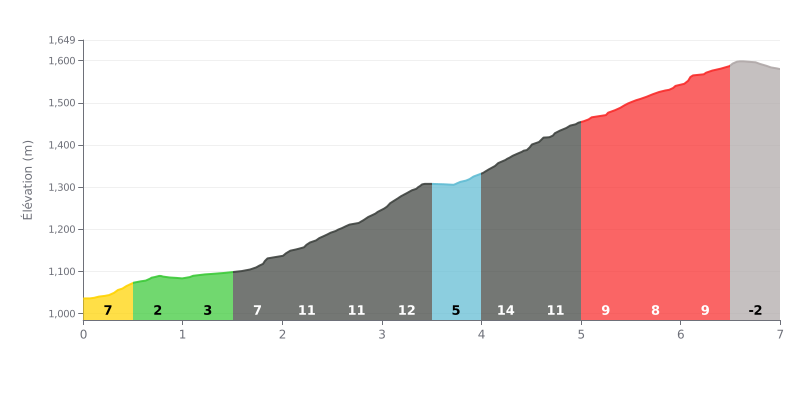
Difficulty analysis: The Mukarimbi climb is a demanding hors catégorie ascent, mainly because of its high average gradient (8.6%) and the three particularly steep kilometres between KM 2.0 and KM 5.0, where the gradient constantly reaches or exceeds 11%, with a peak at 14% between KM 4.0 and 4.5. The final section, a gentle descent (-3%), does not ease the overall difficulty of the effort.
Tips for managing the effort:
1. Pacing: Don't go too hard over the first kilometres, which are more moderate, so you save your legs for the very tough central section (KM 2.0 to 5.0).
2. Anticipate the gradient changes: The gradient varies a lot (from 2% to 14%). Adjust your gear and cadence as you approach the steepest segments, like the 14% km.
3. Focus on the central section: Treat KM 2.0 to 5.0 as the heart of the climb. Hold a steady, controlled effort through this decisive stretch.
7.0 km • 603 m D+
VAM: average climbing speed, based on elevation gain


Join thousands of cycling fans! Plan your rides, record your performance, track your progress and discover the finest climbs.
Live climb profile to pace your effort all the way to the top.

