
Vyshkivskyi Pereval is a climb of 8.5 kilometers (category 1). The climb finishes at 982 m above sea level. It is located in Mîslivka, Івано-Франківська область, Україна. The average gradient is 3.6% with a maximum of 12%. The climb has 308 meters of elevation gain.
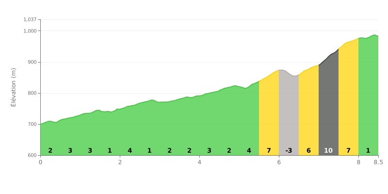
Difficulty analysis: At 8.5 km for 308 m of elevation gain and an average gradient of 3.6%, the Vyshkiv Pass is rated Category 1. The first half is fairly steady, with gradients between 1% and 4% that let you find a consistent rhythm. The real difficulties are concentrated in the final section, between km 5.5 and km 7.5, with gradients of 7%, then 6% and 10%, after the short descent from km 6.0 to km 6.5. The last kilometer, at 1%, gives you a bit of respite before the finish.
Tips for managing the effort:
1. Pace yourself in the first part Keep a moderate effort on the 3% gradients from the start so you have something left for the 10% section between km 7.0 and km 7.5.
2. Recover on the descent Use the short -3% descent between km 6.0 and km 6.5 to catch your breath and get your cadence back up before the 6% ramp.
3. Keep a steady cadence in the final section From km 6.5 to km 8.0, use an easy gear and a smooth cadence, staying seated if you can, to save your legs for the 10% and 7% gradients.
Those who have ridden up the Pereval Vyshkovskiy talk first about the road, and you need to be ready for it. Several describe a stony, steep and beat-up surface that is still passable by car. One report warns that a sedan won't make it, and that it's better to ask locals for the right track, because the GPS gets it wrong. Others mention a new road, or one under resurfacing all the way to Vyhoda. The reports don't agree on the state of the surface, so check before you set off.
Traffic is light. Mostly it's forestry trucks (lesovozy) using this road, with the occasional bus. One rider noted he didn't see a single tourist.
Once at the top, the view lives up to the reports. The viewpoint is a bit higher than the pass sign, continuing on the road that climbs. You get the Carpathian peaks all around, and in winter the scenery turns into a proper snowy postcard. The elevation is given as 931 m in one report and 961 m in another.
At the pass sign, on the main road, one rider says the view is nothing special. A local recommends going up by the dirt track. If you ride early in the morning, through fog or rain, you'll hear the hum of the high-voltage line. Mushrooms and berries grow around the pass, even if the landscape isn't spectacular everywhere.
8.5 km • 308 m D+
VAM: average climbing speed, based on elevation gain


Join thousands of cycling fans! Plan your rides, record your performance, track your progress and discover the finest climbs.
Live climb profile to pace your effort all the way to the top.

