
Thunderbolts Way is a climb of 5.7 kilometers (hors catégorie). Thunderbolts Way tops out at 814 m above sea level. It is located in Mid-Coast Council, New South Wales, Australia. The average gradient is 11.3% with a maximum of 16.1%. The climb has 641 meters of elevation gain.
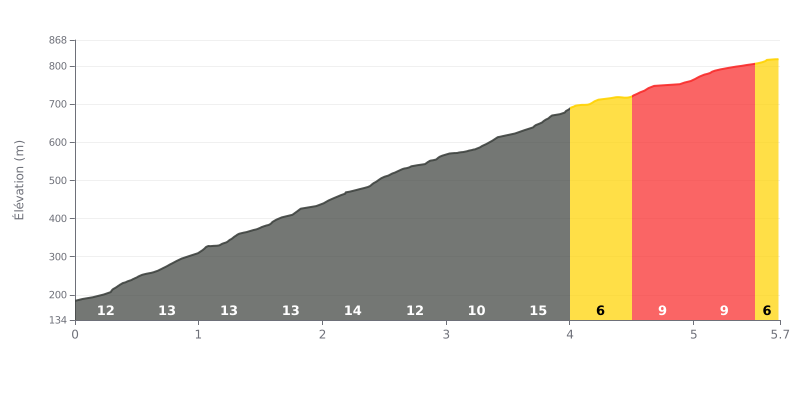
Difficulty analysis: This climb is extremely demanding. An average gradient of 11.3% over 5.7 km puts it clearly in the HC category. The first half is particularly brutal, with gradients between 12% and 14%, peaking at 15% between km 3.5 and 4.0. The stretch between km 4.0 and 4.5 (6%) offers the only real respite before a more moderate finish.
Pacing the effort:
1. Start steady: Resist the urge to go hard on the very steep opening kilometres. Settle into a smooth rhythm, below your threshold, to save your energy.
2. Prepare for the wall: The 15% section (km 3.5-4.0) is the hardest part of the climb. Hit it with fresh legs by managing your effort well before this decisive stretch.
3. Use the respite: Make the most of the 6% stretch (km 4.0-4.5) to recover actively (ease off the power slightly, breathe deeply) before the final section.
5.7 km • 641 m D+
VAM: average climbing speed, based on elevation gain


Join thousands of cycling fans! Plan your rides, record your performance, track your progress and discover the finest climbs.
Live climb profile to pace your effort all the way to the top.

