
Copeland Tops is a climb of 5.5 kilometers (category 1). Copeland Tops tops out at 685 m above sea level. It is located in Mid-Coast Council, New South Wales, Australia. The average gradient is 8.5% with a maximum of 16.4%. The climb has 465 meters of elevation gain.
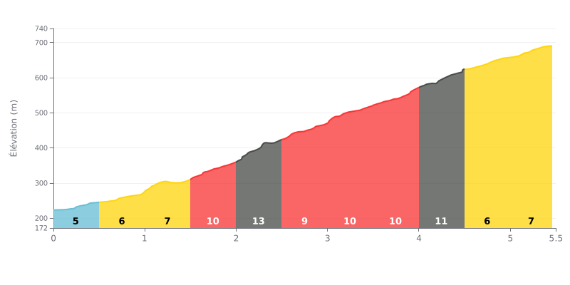
Difficulty analysis: This 5.5 km climb has a demanding profile, with an average gradient of 8.5%. The difficulty lies in how it builds: after a relatively manageable first kilometre (4-7%), the gradient ramps up sharply between the 1.5 km and 4.5 km marks, peaking at 13% over a 500 m section. This three-kilometre stretch at over 9-10% is the heart of the effort.
Pacing advice:
1. Start steady: Use the first 1.5 km (gradients of 4-7%) to settle into your effort without redlining, saving something for the steep sections ahead.
2. Manage your pace through the middle section: Prepare for the hard stretch (KM 1.5-4.5). Select a gear that lets you hold a steady cadence and avoid blowing up your legs on the 10-13% ramps.
3. Stay focused in the final part of the climb: The gradient eases to 7% over the last kilometre, but accumulated fatigue can make this section tough. Don't ease off too early.
Riders who've climbed Copeland Tops describe an immersive, full-on nature experience, far from the hustle. They mention mostly wide trails and a real sense of calm, with the chance to often have the tracks to yourself.
What makes this climb stand out, according to their reports, is the rich history and natural setting along the way. They come across old gold mine remains and vintage mining gear, while riding through a rare dry tropical forest full of ferns, mushrooms and lush undergrowth. Waterfalls and little singletrack spurs down to the river make for some outstanding photo ops.
The ride is described as approachable with plenty of options. You can take a shorter, easier route packed with history, or go for the longer 7 km hike up to the summit, which pays off the effort with stunning views and a run through several different ecosystems.
Riders also highlight the possibility of guided tours of the historic mines, led by dedicated volunteer guides. Even in the rain, these tours are described as captivating, especially for families, making for an educational and engaging outing for kids.
All in all, riders come away from this climb feeling relaxed and recharged. They call the place "superb" and "fabulous" and recommend it as a top pick for a great family day out or an early-morning hike.
5.5 km • 465 m D+
VAM: average climbing speed, based on elevation gain


Join thousands of cycling fans! Plan your rides, record your performance, track your progress and discover the finest climbs.
Live climb profile to pace your effort all the way to the top.

