
Vanrhyns Pass is a climb of 6.6 kilometers (hors catégorie). Vanrhyns Pass tops out at 814 m above sea level. It is located in Matzikama Local Municipality, Western Cape, South Africa. The average gradient is 8.5% with a maximum of 13.4%. The climb has 561 meters of elevation gain.
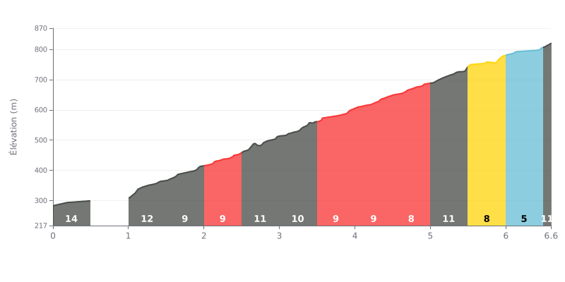
Difficulty breakdown: This 6.6 km HC climb is brutal, with an average gradient of 8.5% and several steep sections. The first kilometre is especially nasty, with a 20% ramp followed by a 10% stretch, and a 12% kick after the 5th km that can shatter your rhythm.
How to manage the effort:
1. Start easy: Hold back over the first 500m at around 4% so you reach the 20% ramp with some legs left.
2. Steady cadence: Find a consistent gear on the 9-10% sections that make up most of the climb, between KM 1.5 and KM 5.0.
3. Save something for the final kick: Keep some power in reserve for the 12% ramp around KM 5.0-5.5, before the gradient eases slightly toward the end.
For riders who've climbed it, the Vanrhynspas is first and foremost a visual reward. Riders' accounts agree on the jaw-dropping views waiting at the top, with recurring mentions of "incredible", "breathtaking" viewpoints or magical moments like finding yourself above the clouds.
The climb itself seems very doable, with several riders describing it as a short climb. The road is described as beautiful, and some have even praised the engineering of the road. The summit offers a pleasant place to stop, with a picnic spot to fully enjoy the panorama.
That beauty comes with a realistic warning shared by several accounts: you need to stay sharp. The heavy truck traffic on the road demands constant attention, especially near the top where you need to park properly to avoid any danger. The descent, in particular, is flagged as requiring extreme caution.
The atmosphere up there is also shaped by an unexpected presence: baboons who, according to one rider, "don't seem very welcoming to visitors". Others have experienced a very different vibe, with thick fog that can completely change the experience.
Despite these points that call for vigilance, the overall impression remains extremely positive. For many, this pass was the highlight of their road trip, a place with a unique charm that makes you want to come back and that you need to take "easy" to soak up its full essence.
6.6 km • 561 m D+
VAM: average climbing speed, based on elevation gain


Join thousands of cycling fans! Plan your rides, record your performance, track your progress and discover the finest climbs.
Live climb profile to pace your effort all the way to the top.

