
Przełęcz Małastowska is a climb of 3.5 kilometers (category 3). The climb finishes at 604 m above sea level. It is located in Małastów, województwo małopolskie, Polska. The average gradient is 5.1% with a maximum of 7.8%. The climb has 181 meters of elevation gain.
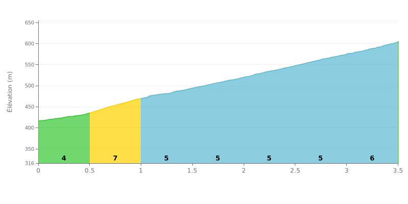
Climb analysis: This 3.5 km climb gains 181 m of elevation with an average gradient of 5.1%. It is rated Category 3 and is moderately hard but consistent. The gradient stays even all the way up, with no real break, so you'll be working steadily the whole time. The steepest section is between KM 0.5 and KM 1.0 at 7%, while KM 2.0-2.5, 2.5-3.0 and 3.0-3.5 hold 6% over the second half of the climb.
Pacing tips:
1. Ease into it Ride the 4% from KM 0.0-0.5 at an easy tempo to save energy for the hardest part.
2. Prepare for KM 0.5-1.0 Tackle the 7% with an appropriate gear and a steady cadence, staying seated to keep your balance.
3. Hold a steady effort Over KM 2.0 to 3.5, at 6%, avoid unnecessary surges and keep your power steady all the way to the top.
The testimonies describe the pass first of all as a good starting point. Several cyclists leave their car in the large forest car park, which is free and spacious, before heading out to the other sites in the area.
The First World War military cemetery, no. 60, comes up in several accounts. Those who have visited it talk about a memorial site that is very well kept, and one of them finds it really beautiful.
For hiking, the summit of Magura Małastowska, at 813 metres, is cited as an option from the pass. The Cafe Magura and Bartne refuges are mentioned as starting points for trails. A shelter with benches has been installed for walkers.
On the road side, the reports say little about the climb itself. One rider mainly remembers the short switchbacks and the top of the pass. None mention traffic, the state of the road surface or how steep the gradient is, so these points still need checking before you set off.
3.5 km • 181 m D+
VAM: average climbing speed, based on elevation gain


Join thousands of cycling fans! Plan your rides, record your performance, track your progress and discover the finest climbs.
Live climb profile to pace your effort all the way to the top.

