
Genting Peres is a climb of 9.6 kilometers (hors catégorie). The climb finishes at 510 m above sea level. It is located in Majlis Perbandaran Kajang, Selangor, Malaysia. The average gradient is 6.3% with a maximum of 16.6%. The climb has 601 meters of elevation gain.
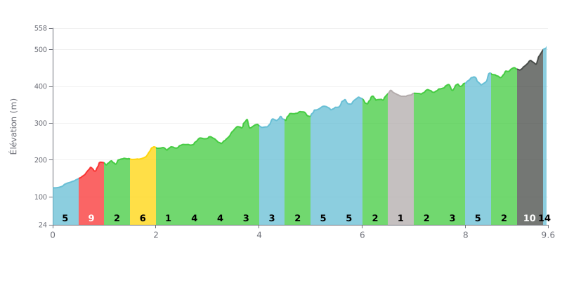
Difficulty breakdown: This HC climb covers 9.6 km at an average gradient of 6.3% and gains 601 m of elevation, making it a long and demanding ascent. The opening is punchy, with 9% from KM 0.5-1.0, after 5% from KM 0.0-0.5. The toughest section comes late, with 11% from KM 9.0-9.5, just when your legs are most fatigued. The 2% stretches from KM 1.0-1.5 and KM 2.0-2.5 do offer some welcome breathing room.
Tips for managing your effort:
1. Pace the start. Don't get carried away from KM 0.0-0.5 and KM 0.5-1.0. Find a strong but sustainable rhythm, because there's still more than 8 km to go.
2. Recover on the rolling sections. Make the most of the 2% stretches at KM 1.0-1.5, KM 2.0-2.5 and KM 4.5-5.0 to top up your glycogen and fluids before the steeper parts.
3. Save something for the finish. Tackle KM 9.0-9.5 at 11% in an appropriate gear, stay seated and keep a steady cadence so you don't blow up your legs.
The climb starts at the police post at the 18th mile, after about ten kilometres through a sleepy village. At the T-junction, turn left and the road kicks up straight away. Those who've ridden it describe a steady climb of around 9 km, with steeper sections and an easier stretch near the orang asli settlement area. The road reopened on 17 November 2023.
The climb winds through dense rainforest, with waterfalls and springs here and there. Several riders mention litter left around, mostly near the waterfalls where people stop. The trail up to Gunung Hitam, near the border marker, is now heavily overgrown.
Traffic is light, if not non-existent for some, especially early in the morning. Reports are mixed, though. One night rider says it's a very quiet road with no traffic at all, while others mention motorbikes and cars passing fast on a narrow surface that isn't really built for bikes and cars sharing it. Some also describe it as a touge road. The surface is slick in places, and for the descent in the dark, only part of the route has reflectors.
Mornings between 5 and 8 a.m. bring mist and fog over the forest, and several riders find this time magical. Many recommend setting off around 7 a.m. Some sections aren't covered by trees, and the sun hits hard quickly. There is no water on the route at all, so bring plenty of water, some bars and sunscreen with at least SPF 30. Toilets are only available in the small cafés near the police post, and there are no shops or houses near the top.
For a beginner, the road gives almost no respite. Stronger riders see it as a great training ground, with plenty of rollers and a few flat stretches to recover on. Some keep going down to Kongkoi, then grind back up 10 km with sections at 7%. Several riders stress that you need to stay sharp on this road.
9.6 km • 601 m D+
VAM: average climbing speed, based on elevation gain


Join thousands of cycling fans! Plan your rides, record your performance, track your progress and discover the finest climbs.
Live climb profile to pace your effort all the way to the top.

