
Taman Pass is a climb of 17.5 kilometers (hors catégorie). Taman Pass tops out at 1,372 m above sea level. It is located in Magelang, Jawa Tengah, Indonesia. The average gradient is 4.3% with a maximum of 14.3%. The climb has 757 meters of elevation gain.
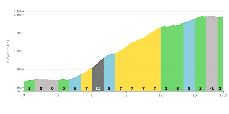
Difficulty analysis: At 17.5 km, with 757 m of elevation gain and an average gradient of 4.3%, the Taman Pass is rated HC. The first four kilometers are mostly rolling (0 to 3%), but the climb gets seriously steep from KM 4.0 to KM 12.0, with gradients between 5% and 11%. The hardest section is KM 6.0-7.0 at 11%, followed by a long block at 7-8% between KM 9.0 and 11.0. The finish is easier (2 to 4%), but offers little respite after that sustained effort.
Tips for the effort:
1. Don't go out too hard. KM 0.0 to 4.0 is rolling terrain: settle into a steady rhythm so you have something left for later.
2. Managing the KM 4.0-12.0 block. On the 5 to 8% ramps, stay seated and keep a smooth, consistent cadence; at KM 6.0-7.0 at 11%, avoid mashing the pedals.
3. Recovering between the surges. Between KM 12.0 and 16.0 (2 to 4% gradients), ride at a moderate pace to recharge before the final effort at KM 17.0-17.5 at 2%.
17.5 km • 757 m D+
VAM: average climbing speed, based on elevation gain


Join thousands of cycling fans! Plan your rides, record your performance, track your progress and discover the finest climbs.
Live climb profile to pace your effort all the way to the top.


Other climbs to Taman Pass