
Kokocz is a climb of 3.0 kilometers (category 2). The climb finishes at 431 m above sea level. It is located in Lubcza, województwo małopolskie, Polska. The average gradient is 6.0% with a maximum of 17.2%. The climb has 181 meters of elevation gain.
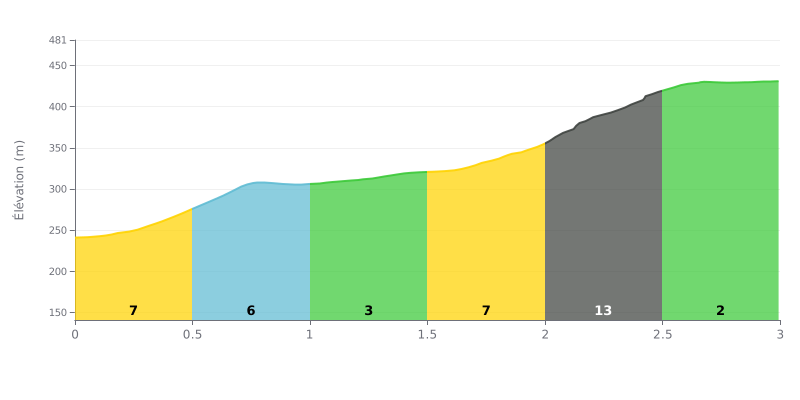
Difficulty breakdown: The Kokocz from Pieglów is a short but demanding climb: 3 km for 181 m of elevation gain, an average gradient of 6%, which earns it a Cat 2 rating. The crux is at KM 2.0-2.5, with a 13% section over nearly 500 m, the key point of the race. The KM 0.0-0.5 and KM 1.5-2.0 stretches, at 7%, already demand a sustained effort, while KM 1.0-1.5, at 3%, gives you a welcome breather.
Tips for the effort:
1. Pace yourself from the start. On the KM 0.0-0.5 section at 7%, settle into a steady rhythm so you have something left for later.
2. Recover on KM 1.0-1.5. Make the most of the gentler 3% gradient to catch your breath and get ready for the steepest part.
3. Tackle KM 2.0-2.5 with the right gear. Select a light gear, stay seated and keep a smooth, steady cadence to get over the 13% without blowing up.
Views come up more than anything else in the reports. From the summit you can see the Brzanka ridge, Mount Liwocz and the Beskids. On clear days some riders claim to spot the Tatras, and one person even mentions the Sandomierz plain to the north. You sometimes have to ride or walk a bit around the top to find a clear view, as the buildings block part of the horizon.
The access road is paved, narrow in places and sometimes steep. You can drive up, and several riders note that there's a fair amount of motor traffic. One report warns to watch out for the tight pinch point at the entrance. Another suggests finishing on foot from Zwiernik or Lubcza. In winter, take it easy on the descent. Several people say the wind is strong at the top.
On site there are benches, a large wiata (shelter), a panoramic terrace, a car park and dry toilets. You can light a fire or a grill, and one person describes spots set up for that. Opinions on maintenance are more mixed, though. The viewing scope is just a damaged leftover. The triangular shelter has a wasp nest near the entrance. Some find the place neglected or vandalised, and others regret that nobody looks after it. Two people say the power poles spoil the scenery.
The tężnia solankowa (open-air brine inhalatorium) comes up often. For many it's a nice surprise and a real bonus. But it doesn't always work. One report describes it dry, another has it without water, and a third saw it start up an hour after arriving. A plan for an observation tower has been mentioned several times, but it hasn't been built yet.
The atmosphere is calm, especially early on a Sunday morning when you can hear the birds. The spot works well for picnics and family outings, including with a pushchair. One person recounts taking part in a local festival, the Święto Grzybiarza, in a great atmosphere. There's no shop and no water point on site, so bring your own supplies.
3.0 km • 181 m D+
VAM: average climbing speed, based on elevation gain


Join thousands of cycling fans! Plan your rides, record your performance, track your progress and discover the finest climbs.
Live climb profile to pace your effort all the way to the top.


Other climbs to Kokocz