
Przełęcz nad Roztokami Górnymi / Ruské sedlo is a climb of 3.6 kilometers (category 3). The climb finishes at 793 m above sea level. It is located in Liszna, województwo podkarpackie, Polska. The average gradient is 4.1% with a maximum of 8.9%. The climb has 150 meters of elevation gain.
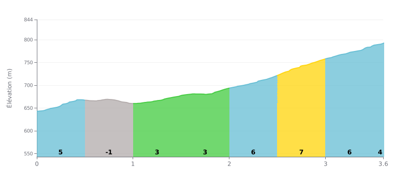
Difficulty breakdown: At 3.6 km for 150 m of elevation gain and an average gradient of 4.1%, this Category 3 climb is very doable, but it asks for sustained effort from bottom to top. The hard part sits between KM 2.0 and KM 3.5, where the gradient bounces between 6% and 7%, with the KM 2.5-3.0 section at 7% being the toughest. The descending stretch from KM 0.5-1.0 at -2% gives you a bit of breathing room halfway up.
Tips for managing your effort:
1. Pace the start: from KM 0.0-0.5 at 5%, don't go out too hard. Save something in the tank for what comes next.
2. Make the most of the descent: on KM 0.5-1.0 at -2%, spin the legs easy, grab a drink and recover without fully switching off.
3. Handle KM 2.5-3.0: shift into an easier gear, stay seated if you can, and keep a steady cadence to get through the 7% without blowing up.
Sedlo Ruska can be tackled from two sides, and the accounts don't describe them the same way. From the Slovak side, the climb follows a rocky, gravel track, more demanding, which gravel riders tend to enjoy. From the Polish side, a paved road climbs from Majdan through Liszna, with a small car park for those who walk up.
Riders who made it to the top mostly talk about the view. There is an observation tower, but no bench and no shelter. One rider watched the sun set on the Polish side while the moon rose over the Slovak side, and another remembers the star-filled nights fondly. One person found the place "nostalgic".
It isn't always quiet. One person described it as "absolutely nobody around", but another said there were plenty of people up there this year. Several riders also note that you can drive up on the Polish side, and the access road is described as narrow.
Nearby there's the Cicha valley, with only a handful of chalets, and Lemko villages on the Slovak side. One rider recommends going once the pandemic is over, with a cold draft beer. The pass was once a trade route between Lesser Poland and Hungary.
On foot, the climb is doable for a family. A hiker who has been making the trip for several years says an 8-year-old child can get up there without any problem.
3.6 km • 150 m D+
VAM: average climbing speed, based on elevation gain


Join thousands of cycling fans! Plan your rides, record your performance, track your progress and discover the finest climbs.
Live climb profile to pace your effort all the way to the top.

