
Rooihoogtepass is a climb of 8.0 kilometers (category 2). Rooihoogtepass tops out at 1,242 m above sea level. It is located in Langeberg Local Municipality, Western Cape, South Africa. The average gradient is 4.9% with a maximum of 11.1%. The climb has 392 meters of elevation gain.
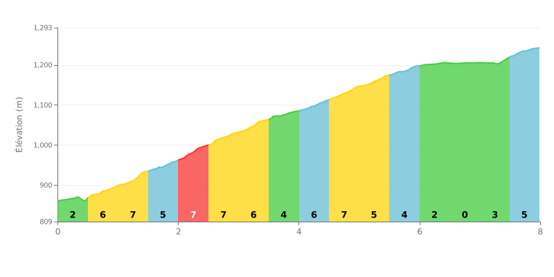
Climb analysis: This 2nd category climb is moderately hard but uneven. The first half (KM 0-4) is the most demanding, with gradients between 6% and 8%. A notable breather comes between KM 6.0 and 7.0 (gradients of 0% to 1%), before a slightly steeper finish (3% to 5%).
Tips for pacing your effort:
1. Managing the start: Don't go out too hard over the first kilometers at 6-7%. Settle into a steady rhythm to save your legs for later.
2. Making the most of the flat: Use the almost flat section (KM 6-7) to recover, get some fluids in, and ease the pressure on your legs before the final climb.
3. Ramping back up: Anticipate the return to the gradient after the breather (KM 7-8) by gradually raising your cadence so you're not caught off guard.
8.0 km • 392 m D+
VAM: average climbing speed, based on elevation gain


Join thousands of cycling fans! Plan your rides, record your performance, track your progress and discover the finest climbs.
Live climb profile to pace your effort all the way to the top.

