
Alto del Vino is a climb of 28.7 kilometers (hors catégorie). The climb finishes at 2,541 m above sea level. It is located in La Vega, Cundinamarca, Colombia. The average gradient is 5.6% with a maximum of 14.2%. The climb has 1618 meters of elevation gain.
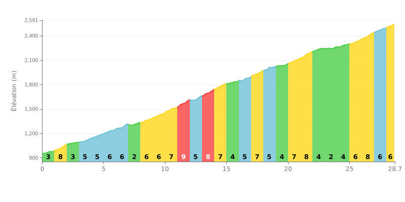
Climb analysis: The Alto del Vino is a HC climb covering 28.7 km with 1618 m of elevation gain, at an average gradient of 5.6%. The start is rolling (3% from km 0-1, 2% from km 7-8), but the real work begins at km 8 with a string of sections between 6% and 9%, the hardest being km 11-12 at 9%. The second half stays tough, with 8% at km 21-22 and km 26-27, and the km 28-28.7 section at 6% means you need to keep something in the tank right to the end.
Pacing tips:
1. Don't go out too hard. On the early 3% kilometres (km 0-1 and km 2-3), keep the pedalling easy so you hit the 8% at km 1-2 with fresh legs.
2. Manage the middle section. Between km 8 and km 14, where the gradient swings between 5% and 9%, run a fairly small gear and hold a steady cadence of 70 to 80 rpm.
3. Save something for the finish. On the 8% at km 26-27 and then the 6% at km 28-28.7, avoid pointless accelerations and save your legs for the last few hundred metres.
Those who have climbed the Alto del Vino put the summit at around 2800 meters, between Bogotá and La Vega, and it's often reached from Soacha. It gets quite cold up top. Opinions on difficulty are split: some riders say the climb is tough, with steeper sections than you'd expect, while others call it an easy gradient, good for beginners or for base miles.
The road is wide and in good condition, and several riders say there's no traffic jams. But the traffic is heavy: trucks, cars and motorbikes come through fast, and there are a lot of cyclists, especially at weekends. Several recommend riding with great caution. There's also plenty of wind. One rider suggests bringing a wind jacket for the descent, which he finds spectacular.
Food and drink stops come up again and again in the reports. There are numerous stalls where you can grab breakfast, a bite to eat, a glass of orange juice, a hot or cold drink, and buy bread. Prices are considered reasonable, sometimes a bit on the high side. There are public toilets and a parking area, but one of them is considered unsafe because it sits right against the road. Others feel secure thanks to how busy the spot is.
Many local cyclists train there or do their Sunday ride there. Some recommend it as your first proper big climb, while others describe it as a serious challenge. One rider says he first rode it 45 years ago with friends, and even ended up racing them to the top. Another climbed it while fighting the flu. If you're riding on a weekday, bring a puncture repair kit.
28.7 km • 1618 m D+
VAM: average climbing speed, based on elevation gain


Join thousands of cycling fans! Plan your rides, record your performance, track your progress and discover the finest climbs.
Live climb profile to pace your effort all the way to the top.


Other climbs to Alto del Vino