
El Cimatario is a climb of 2.9 kilometers (category 3). The climb finishes at 2,403 m above sea level. It is located in La Noria, Querétaro, México. The average gradient is 6.0% with a maximum of 14.7%. The climb has 175 meters of elevation gain.
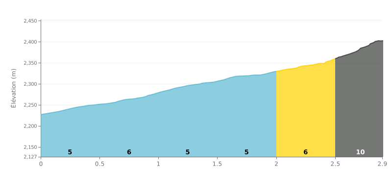
Difficulty breakdown: At 2.9 km and 175 m of elevation gain, this 3rd-category climb averages 6%. It's a tough one, but there's no real steep wall for most of the way. The sections km 0.0-0.5, km 1.0-1.5 and km 1.5-2.0 at 5%, plus km 0.5-1.0 and km 2.0-2.5 at 6%, keep a steady grind on the legs that wears you down bit by bit. The real test is km 2.5-2.9, at 10%, where the gradient really kicks up over 415 m.
Pacing tips:
1. Pace yourself from the bottom: over the first two kilometers at 5-6%, stay in the aerobic zone so you've got something left for the end of the climb.
2. Keep a steady cadence on km 2.0-2.5: at 6%, pick a gear that lets you spin smoothly rather than mashing the pedals.
3. Prepare for the 10% section: over the last 415 meters, get seated, keep your shoulders relaxed and dig into your reserves without going into the red too early.
The testimonies about this climb are mostly about a hike. The longest route to reach the lookout is 7 km, and one cyclist describes it as not too steep. Another finds it demanding. Riding a bike is possible, but the trail is paved with stones, and one visitor advises wearing good shoes so you don't hurt yourself.
The view over Querétaro and its surroundings comes up in nearly every account. When it's all green, you can see the whole city, and several people say it's worth the effort. The sunrise is also mentioned. According to one person, the spot is still beautiful with sun, under clouds, or in the rain.
For mountain biking, one rider finds the place excellent for XC, with a bit of enduro. He recommends bringing at least 2 liters of water. There's nothing to pay, you just have to register for safety reasons, and the staff is described as friendly. The trails are signposted.
On site, people talk about calm at the top, family outings, and deer visible in the park, sometimes other animals too. The park is described as clean and protected. One person says being in nature gave them back their energy.
One testimony points to a serious problem: a person named Luis damaged the flora by drawing on the plants. The visitor who tells this was very bothered by the situation and asks people who do this kind of thing to stop.
2.9 km • 175 m D+
VAM: average climbing speed, based on elevation gain


Join thousands of cycling fans! Plan your rides, record your performance, track your progress and discover the finest climbs.
Live climb profile to pace your effort all the way to the top.

