
Nagrak Mountain is a climb of 23.1 kilometers (hors catégorie). The climb finishes at 1,810 m above sea level. It is located in Kumbalgama, Sabaragamuwa Province, Sri Lanka. The average gradient is 7.4% with a maximum of 15.2%. The climb has 1699 meters of elevation gain.
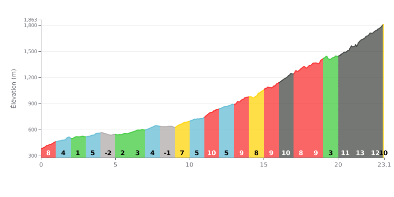
Difficulty analysis: With 23.1 km for 1,699 m of elevation gain and an average gradient of 7.4%, the Nagrak Mountain is rated hors catégorie. The first part, up to km 9, is more manageable with sections between 2% and 5%, broken up by two short descents (km 4-5 and km 8-9). The difficulty kicks in from km 9 onwards: from km 9 to km 23, the gradients mostly range between 7% and 13%, with a particularly tough finale from km 20 to km 23 (11% to 13%).
Tips for pacing yourself:
1. Manage your effort until km 9. The 2% to 5% sections tempt you to go hard, but you need to keep a controlled rhythm so you reach km 9 with something left in the tank.
2. Use the descents to recover. The km 4-5 and km 8-9 descents are the perfect chance to drink, eat something and drop your shoulders before getting back on the climb.
3. Prepare for the 13% finale. Shift into an easier gear from km 19-20, keep a steady cadence and avoid surging on the 11% stretch between km 20 and 21.
The accounts are clear about access: the road to Nagrak is an off-road track that ordinary cars can't handle. Those who've done it talk about 4x4s, safari jeeps or trail bikes. None mention cycling, so these are all reports from motorized folks.
The summit sits at about 6,990 feet (2,130 m). The most common highlights are the valley views and distant mountains, with misty landscapes and crisp air. Several people say the weather changes quickly up there and that the place is peaceful. Coming from Baker's Bend, you reach a three-way junction: one road goes to Belihuloya, the other to World's End.
The most frequently mentioned downside is the road condition, described as poor, with broken, slippery sections, especially after rain. It's advised to avoid periods of heavy rain. There's no shop or services on site, so bring water, snacks and the essentials.
One account describes a hike of about 5 km from the village of Ihala Galagama, with a small snack stall where you can grab tea, biscuits and snacks. The site is near the Horton Plains base, and those who write about it stress how fragile the environment is: pollution, vandalism and disturbance should be avoided. An experienced driver or a guide is recommended.
23.1 km • 1699 m D+
VAM: average climbing speed, based on elevation gain


Join thousands of cycling fans! Plan your rides, record your performance, track your progress and discover the finest climbs.
Live climb profile to pace your effort all the way to the top.

